Griffin, W.L.1,2, Doyle, B.J.3, Ryan, C.G.2,1, Pearson, N.J.1, O'Reilly,
S.Y.1,
Natapov,L.1, Kivi, K.4, Kretschmar, U.5 and Ward, J.6
1. GEMOC National Key Centre, School of Earth Sciences, Macquarie University,
NSW 2109, Australia
2. CSIRO Exploration and Mining, P.O. Box 126, North Ryde, NSW
2113, Australia
3. Kennecott Canada Exploration Inc., 200 Granville St., Vancouver,
B.C. V6C 1S4, Canada
4. Kennecott Canada Exploration Inc., 1300 Walsh St., Thunder Bay,
Ontario P7E 4X4, Canada
5. Kretschmar Geoscience, 408 Bay St., Orillia, Ontario
L3V 3X4, Canada
6. Ashton Mining of Canada Inc., Unit 123-930, West 1st St.,
North Vancouver, B.C. V7P 3N4, Canada
Xenoliths and heavy mineral concentrates (>1500 garnets and chromites
from 21 kimberlite intrusions) were used to map the composition, structure
and thermal state of the lithospheric mantle beneath the Lac de Gras area.
P-T estimates for xenoliths from the A154 pipe, combined with those of
Boyd and Canil (1997) for the Grizzly pipe, define a geotherm that is close
to or below a 35 mW/m2 conductive model geotherm for temperatures <900
°C, and close to a 38 mW/m2 model at T *900 °C (Pearson et al.,
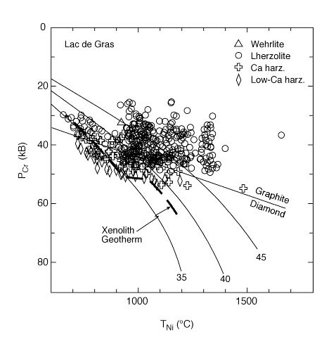
this volume). P-T estimates based on garnet and chromite concentrates
(Ryan et al., 1996) define a similar stepped geotherm (Fig.
1), which may separate two layers with different conductivity.
High-T sheared xenoliths are present, but do not define a "kink"
in the geotherm.

Fig. 1. P-T plot for garnet xenocrysts
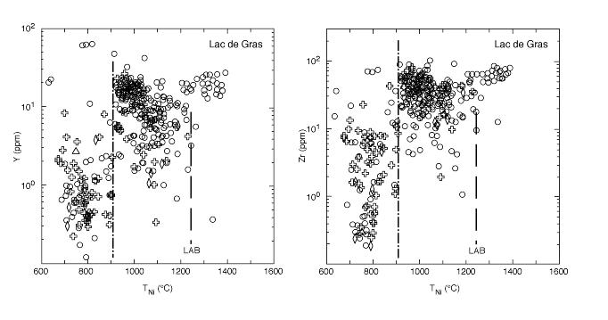
A boundary between two layers of the lithospheric mantle is well
defined by plots of trace- and major-element data vs Nickel Temperature
(TNi) for concentrate garnets (Fig. 2). Projection
of the temperature of this boundary to the geotherm derived from xenoliths
and concentrates places it at a depth of 150±10 km beneath the Lac
de Gras area. Both harzburgitic and lherzolitic garnets from the
shallower layer have extremely low levels of Y, Zr, Ti and Ga. The
median contents of these elements (Ti, 380 ppm; Y, 1.5 ppm; Ga, 4 ppm,
Zr, 5 ppm) are lower than 90% of the values found in garnets from Archean
cratons worldwide (Griffin et al., 1998), indicating that this layer is
ultradepleted. The garnets of the deeper layer are more typical of
Archean garnets worldwide (median Ti, 1800 ppm; Y, 8 ppm; Ga, 8 ppm, Zr,
33 ppm), and depleted compositions like those of the shallower ultradepleted
layer are rare in the deeper layer. A small population of garnets
with Ti-Zr-Y rich signatures characteristic of high-T sheared xenoliths
suggests that the base of the (chemically defined) lithosphere has TNi
= 1200-1250 °C, corresponding to 200-220 km beneath the central part
of the Lac de Gras area.
Garnet and chromite data and available xenoliths indicate that
the shallower layer consists of approximately 60% harzburgite and 40% lherzolite,
both with similar olivine compositions (mean Fo=92.7). At depths
shallower than 100 km, garnet disappears and the Al-Cr phase is spinel.
The deeper layer of the lithospheric mantle contains <17% harzburgite,
and most of this is concentrated in the upper part of this layer (Fig.
2); mean olivine composition is Fo=91.5. T estimates on xenoliths
indicate that all eclogites are derived from the deeper layer, but are
bimodally distributed with Al-rich compositions near the bottom of the
layer, and Al-poor compositions near the top (Pearson et al., this vol.).
The two-layered lithospheric structure has been mapped in detail
over an area ca 60x30 km around Lac de Gras, and is consistent from
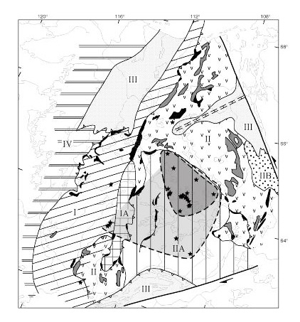
pipe to pipe. The wider lateral extent of this structure (Fig.
3) has been mapped using concentrates from outlying pipes, including
the Ranch Lake pipe to the north, the Cross Lake cluster to the SW, the
Drybones pipe near Yellowknife, and isolated exploration samples.
Limited data from pipes A44 and PL01 indicate that the two-layer structure
extends at least 50 km E and NE from Lac de Gras. This
structure also is well-defined beneath the Ranch Lake pipe, ca 80 km NW
of Lac de Gras, where the boundary is at ca 140 km depth. However,
at Ranch Lake the base of the (chemically defined) lithosphere has shallowed
to ca 170 km, and the proportion of harzburgite in both the shallower and
deeper layer has decreased.

Fig. 2. Y and Zr vs TNi for garnets, showing the two lithosphere layers, and the LAB boundary. Symbols as in Fig. 1
Concentrate garnets from the Camsell Lake area, 100 km S of Lac
de Gras (Pokhilenko et al., 1997) do not include the population of low-Ca,
moderate-Cr harzburgitic garnets that characterises the shallow layer beneath
Lac de Gras. The range of FeO contents in the Camsell Lake garnets
also requires relatively fertile lherzolitic material at shallow depth,
and the proportion of G10 garnets in the concentrate is 15-17%, as in the
deeper layer beneath Lac de Gras. The distribution of CaO contents
in low-Cr garnets also is bimodal at Camsell Lake, as in the deeper layer
at Lac de Gras. These data suggest that the shallow ultradepleted
layer is absent, or is < 100 km thick, in the southern part of the craton,
and that most of the lithospheric mantle consists of material similar to
the deeper layer beneath Lac de Gras.
Ultramafic xenoliths from the Jericho pipe, ca. 80 km N of Ranch
Lake, are lherzolitic, with relatively low-Cr garnets (Kopylova et al.,this
vol.). The TNi distribution of Cr, Zr and Y contents of garnet
shows that the shallow ultra- depleted layer is absent, and the stratigraphy
and garnet composition are characteristic of Proterozoic, rather than Archean,
mantle (Griffin et al., 1998). This suggests a major boundary in
the lithospheric mantle, which may correspond to the position of the Proterozoic
Kilohigok Basin.
Concentrate garnets from the pipes of the Cross Lake cluster
define a 38 mW/m2 geotherm similar to that in the deeper layer of the Lac
de Gras section, but without any step; the base of the lithosphere lies
at ca 180 km. The ultradepleted upper layer is absent, or <100
km thick; the depth range 100-140 km is occupied almost entirely by moderately
depleted lherzolites. The analysed section contains ca 16% harzburgite
(as defined by "G10" garnets), concentrated in the depth range 140-160
km, and the median garnet Cr, Zr and Y contents are similar to those of
the deeper layer beneath Lac de Gras. High-Ca eclogitic garnets are
present, but the bimodal distribution seen in the Lac de Gras sections
is not evident.
Peridotitic garnets from the Drybones pipe on the SW margin of
the craton are derived entirely from <140 km depth, and are are lherzolitic,
with a median Cr2O3 content of ca 5%. Many garnets from depths <130
km are depleted in Zr and Y, but the lack of harzburgitic garnets in this
layer distinguishes it from the mantle at similar depths beneath
Lac de Gras. This section is most typical of Proterozoic, rather
than Archean, lithospheric mantle.
The shallow, ultradepleted layer of the lithospheric mantle has
been mapped over an area of at least 18,000 km2 centred on Lac de
Gras (Fig. 3). It appears to be absent, or <100
km thick, beneath the SE part of the craton, and apparently does not cross
the Sleepy Dragon Belt to the Cross Lake area. The deeper layer appears
to extend further, rising to depths ?120 km beneath the Camsell Lake
and Cross Lake areas. The shallow layer is interpreted as lithosphere
formed in a convergent-margin setting, analogous to modern depleted sub-arc
mantle, during the 2.75-2.6 Ga accretion of the eastern part of the Slave
craton to the existing continental nucleus of the western part. The
deeper layer of the lithospheric mantle contains many diamonds (=25% of
the population) with the ultradeep ferropericlase-Mg-perovskite assemblage
(Davies et al., this volume), many eclogitic diamonds with very low *13C,
and kyanite eclogite xenoliths with anorthositic-troctolitic compositions
(Pearson et al., this volume), suggesting a component of recycled crustal
material. This deeper layer is interpreted as the head of a plume
or diapir, incorporating both moderately depleted mantle and subducted
crustal material, that has risen from >650 km depth to accrete onto the
base of the craton. The pre-existing lithosphere was ca 150 km thick
and ultradepleted beneath the centre of the craton (Fig. 3),
but thinner and/or less refractory to the S and SW. This mantle-underplating
event may be related to the widespread post-orogenic (2.5-2.6 Ga) granitoid
magmatism in the Slave Province, and heat from this event may have caused
further depletion of the shallow layer where it was present.
The apparently Proterozoic lithospheric mantle beneath the Jericho
pipe may represent older lithosphere reworked during the Mackenzie plume
event (1.27 Ga); similar mantle is reflected in garnet concentrates from
kimberlites on Victoria Island, closer to the plume focus (this work).
Alternatively, it may have been generated during rifting processes that
led to the formation of the Proterozoic Kilohigok Basin. The mantle
sampled by the Drybones pipe on the SW corner of the craton is not typically
Archean; it may have been reworked or replaced during Proterozoic subduction
from the west, or during transcurrent movement along the major MacDonald
Fault.

Fig. 3. Terrane map of Slave Craton, showing minimum extent of the shallow ultradepleted layer (dark shading) and of the deeper less depleted layer (light shading). I, Anton Terrane (ancient continental core); IA, Sleepy Dragon domain; II, Hackett River Terrane (island arcs); IIA, Contwoyto Terrane (accretionary prism); IIB, Beechy Lake domain; III, passive margins, Kilohigok Basin (Proterozoic cover); IV, Proterozoic mobile belt.
References
Boyd, F.R. and Canil, D., 1997. Goldschmidt Conf. Abstracts, 34-35.
Griffin, W.L., Doyle, B.J., Ryan, C.G., Pearson, N.J., O'Reilly, S.Y,
Davies, R., Kivi, K. and van Achterbergh, E., 1998. Jour. Petrol.,
subm.
Pokhilenko, N.P., McDonald, J.A., Melnik, U., McCorquodale, J., Reimers,
L.F. and Sobolev, N.V., 1997. Russian Geology and Geophys., 38, 550-558.
Ryan, C.G., Griffin, W.L. and Pearson, N.J., 1996. Jour Geophys. Res.,
101, 5611-5625.

 GEMOC ARC National Key Centre