 GEMOC ARC National Key Centre
 |
 |
 |
 |
Research highlights 2000
- TerraneChron™ - zircons barcode the crust for correlation and exploration
- TerraneChron™ reveals the development of the Mt Isa Eastern Succession
- How to make a Craton: TerraneChron™ in the Yilgarn
- Zircons reveal magma source rocks for the New England Batholith granites
- How old is the Slave Craton mantle?
- Diamond fingerprints - for science and peace
- Heard Island: piecing together the evolution of the Kerguelen-Heard plateau
- Composition of groundwaters: an insight into sub-surface temperatures
- Barcoding the mantle: basalts as probes to Earth's geodynamics
- The Slave Craton (Canada) in deep analysis
- The new GEM in GEMOC - the GJ-1 zircon standard
- Superdeep diamonds
- A key palaeomagnetic pole for the Early Permian for Australia and Gondwana
- Sorting out the mantle: In situ measurement of Re-Os isotopes in mantle sulfides by LAM-MC-ICPMS
- Partition coefficients-essential ingredients
for modelling the geochemical evolution of the crust-mantle system.
(for Numbered publications see Appendix 2)
TERRANECHRON™ - ZIRCONS BARCODE THE CRUST FOR CORRELATION AND EXPLORATION
Modern field geology, based on an understanding of plate tectonics, has shown that most of our continents are made up of fragments (terranes), assembled at different times, then broken up, moved and re-assembled. The ambiguity of many plate reconstructions, particularly back beyond Phanerozoic time, can be constrained if we have a way of recognising blocks of crust with equivalent genetic histories. This has practical consequences as well if we want to find the next Broken Hill or Mt. Isa, we need to look for blocks of crust with similar histories of crustal development. In effect, we need be able to match up geological "barcodes" of individual terranes. Field geology, even assisted by geochronology, can only go part of the way commonly there are too few bars in the code to provide unambiguous matches.
GEMOC, working together with Dr Steve Walters of Advantage Geochemical Solutions (AGS) has applied its in situ analytical capabilities to develop a better barcoding method, applicable at scales from individual drainages to large continental areas. The technique uses suites of detrital zircons from modern drainages. Each zircon is precisely dated using GEMOC's LAM-ICPMS techniques; this tells When material was added to the crust. Then in situ analysis of Hf isotopes in each grain by LAM-MC-ICPMS tells How the material got there juvenile addition from the mantle, or reworking of old crust. A suite of trace elements (Hf, Y, Th, U, Lu, Yb) collected during the other analyses identifies the original host rock of each zircon, telling What sort of material was added. The resulting Event Signature (see Mt Isa and Yilgarn) gives a detailed picture of the formation of the block of crust, which can be compared with similar data from other blocks. Beyond the direct correlation applications, there lies the possibility of predictive mineral exploration, based on the recognition of the Event Signatures of "fertile" and "barren" metallogenic provinces globally. GEMOC is in discussion with the mineral industry and other end-users to raise support for a program of comparative analysis of such provinces.
TERRANECHRON™ REVEALS THE DEVELOPMENT OF THE MT ISA EASTERN SUCCESSION
ESTABLISHING A GEOCHRONOLOGICAL FRAMEWORK is an important component in characterising terrane evolution and correlating events. This can include time slices associated with known metallogenic endowment or recognition of 'fertile' crustal histories of direct interest for terrane assessment in regional mineral exploration. Recent advances in laser ablation microprobe ICPMS (LAM-ICPMS) make it possible to obtain in situ U-Pb age data comparable in quality with ion microprobe analyses, but more quickly and at lower unit cost, making it feasible to analyse large grain populations. The TerraneChron™ concept developed by GEMOC and Advantage Geochemical Solutions (AGS) (and described in a separate feature article in the Research Highlights) has been used to define a detailed Event Signature for the Soldiers Cap 'Terrane' in the Mount Isa Eastern Succession based on detrital heavy mineral sampling.
The area was selected due to its obvious economic interest as host to the world-class Cannington Ag-Pg-Zn deposit and several Iron Oxide Cu-Au deposits. The region has been the focus of intensive research including SHRIMP U-Pb dating that has defined a broad chronostratigraphic framework. Ten heavy mineral samples(ca 500 zircons) were collected to cover the main outcrop extent of the mapped Soldiers Cap Group and adjacent units.
The TerraneChron™ U-Pb results show good agreement with the age spectra predicted from correlations of SHRIMP data with the mapped geology of sample drainages. Individual lithostratigraphic units can be recognised not only by their age spectra, but also in several cases by distinctive zircon chemistry (trace elements, Hf-isotope signature). Metasediments in the Soldiers Cap-Fullarton River Groups commonly show multiple populations that reflect provenance. The presence of abundant inherited zircons allows reconstruction of a crustal evolution history extending back to Late Archean time, despite the fact that the host units do not substantially outcrop in the sampled areas. Modelling of composite age spectra allows definition of eight major Proterozoic geochronological events in the Eastern Succession, spanning the period 1400-1950 Ma, and these correspond broadly to events recognisable in the existing SHRIMP database. A more sophisticated Event Signature has been defined by integration of the Hf-isotope and trace element data (Fig. 1). This suggests four major stages of crustal evolution 2550-2330 Ma, 1950-1825 Ma, 1800-1600 Ma and 1590-1420 Ma. Each stage has a distinct pattern of crustal generation: the relative importance of juvenile mantle input relative to reworking of older crust increases with time, as does the degree of mixing between older crust and juvenile material, and the first three cycles each ends with a period of crustal homogenisation. This history of cyclic rifting with juvenile additions followed by homogenisation is a distinctive pattern of crustal evolution; in the case of the Mount Isa Inlier it is linked to world-class metal endowment involving a range of metallogenic styles. The challenge for the future is to develop a 'library' of comparative Event Signatures for known endowed versus barren terranes within these time slices to determine the predictive economic significance of this pattern.
Contact: Bill Griffin, Elena Belousova, Simon Jackson, Sue
O'Reilly, Steve Walters
Funded by: Industry Collaborative projects (BHP, Anglo, WMC),
Macquarie University
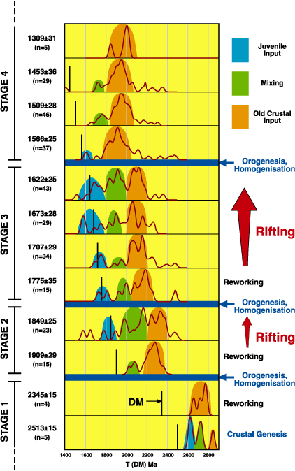
'Event Signatures' at the Mount Isa Eastern Succession. Time slices determined by zircon U-Pb dating are plotted against T(DM) model ages, where DM represents the depleted mantle line. Age peaks are grouped into material derived from juvenile (depleted mantle) sources, reworked old crust and mixtures of both, for each period.
HOW TO MAKE A CRATON: TERRANECHRON™ IN THE YILGARN
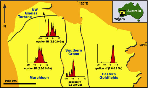
THE TERRANECHRON™ APPROACH (integrated U-Pb dating, Hf-isotope analysis and trace-element spectra on suites of detrital zircons see TerraneChron™ Feature Article) offers a new way to look at the development of Precambrian cratons. In a reconnaissance study, GEMOC has analysed over 600 zircons from modern drainages along a traverse across the northern end of the Yilgarn Craton; the zircon separates were prepared from diamond exploration samples by DeBeers Australia Exploration Pty Ltd. The samples cover the NW Gneiss Terrane, the Murchison Province, the Southern Cross Province and the Eastern Goldfields Province. The results show major differences in crustal evolution and the history of crust-mantle interaction among the different provinces.
In the Eastern Goldfields Province continental crust probably did not exist before 2.9 Ga ago, and most of the magmatic rocks produced at 2.6-2.8 Ga were derived from a Depleted Mantle source. In the Southern Cross Province (Barlee Terrane), juvenile crust formed at 3.6-3.7 Ga and again at 3.3-3.4 Ga, and this older crust was reworked to produce granitoid magmas at 2.5-2.7 Ga. In contrast to the adjacent Eastern Goldfields Province, there is no evidence of a juvenile (mantle) contribution to the crust during the major 2.5-2.7 Ga magmatism. In the Murchison Province, juvenile crust formed at least by 3.3-3.5 Ga; this older crust was reworked at 2.6-2.8 Ga, but significant juvenile crust was also added during this time. In the NW Gneiss Province, juvenile crust probably formed by 3.5 Ga, and again between 2.8-3.0 Ga, but younger granitoids (2.4-2.8 Ga) were derived mainly by crustal reworking. These different crustal evolution histories suggest that the NW Gneiss Province, Murchison Province and Southern Cross Province represent separate micro-continental fragments with very different geological histories. These older fragments were swept together to form the nucleus of the Yilgarn continent, and the Eastern Goldfields Province was accreted (as a series of arcs?) to the continental margin between 2.8-2.9 Ga.
The data also contribute to a picture of the development of the early Earth. The oldest rocks in the Murchison and Southern Cross provinces were derived from a chondrite-like mantle source, suggesting that little continental crust had been extracted before 3.5 Ga. A Depleted Mantle source had developed beneath the Southern Cross Province ca 3.3 Ga ago, but may not have appeared under the NW Gneiss Terrane and the Murchison Province until ca 3.1 Ga ago.
The data on the zircons from the 2.5-2.7 Ga granitoids suggest that the presence of older crust strongly influenced the nature of crust-mantle interaction during the assembly of the craton and the accompanying major magmatism. These differences in the style of crust-mantle interaction also correlate strongly with known mineral potential: more mantle input, more mineralisation.
Contact: Bill Griffin, Elena Belousova, Sue O'Reilly
Funded by: ARC, Stockdale Prospecting
Distribution of
ZIRCONS REVEAL MAGMA SOURCE ROCKS FOR THE NEW ENGLAND BATHOLITH GRANITES
GRANITES MAY CRYSTALLISE from a single magma or from several magmas that mix. The relative importance of magma(s) sourced from either the crust or mantle is a major debate with important implications for the mechanism of continental growth. New micro-analysis techniques for hafnium isotopes in zircons from granite allow the recognition of those zircons that have crustal signatures and those that have mantle signatures. In addition, the TerraneChron™ technique developed recently in GEMOC (see item in Research Highlights) can provide rapid in situ zircon U/Pb age determination as well as the Hf176/Hf177 ratios. The granites of the New England Batholith have few zircons that are inherited from older rocks and therefore the 176Hf/177Hf zircon data provide a measure of the time since the source rock was generated from the mantle.
Preliminary data for one I-type granite have resolved a major controversy by confirming that it is formed mainly from a melt with a distinctively crustal Hf isotopic signature. However, a second group of zircons from the more felsic part of the granite was found to have Hf isotopic ratios indicating involvement of a magma derived either from the mantle or a very young crustal source (eg young mantle-derived mafic intrusions into the lower crust). The surprise was not that at least two magma types are involved but rather that the magma derived from the mantle (or very young crust) is felsic and not mafic. Thus the zircon evidence suggests the mixing of two felsic magmas without a mafic melt component. This observation has potentially significant implications for the origin of most granites and the type of melts involved in mixing processes. New data are expected to resolve unambiguously whether granites that form so much of the upper crust in eastern Australia are (a) formed by recycling older crustal materials or (b) are significantly new material added from the mantle below.
We will now examine the other five supersuites (groups) of New England Batholith granites to determine if this source rock diversity is general. Our aim is to find whether a mix of magma types is common in other granite types of the New England Batholith and especially whether a mantle-derived felsic magma may be a significant component of S-type granites, thus explaining chemical differences between S-type granites and the regional metasediments. The extent to which the Hf isotopic data differ in the six different granite groups is important and we would predict from the available other isotopic data that the age of the crustal source rocks and/or the relative importance of the mantle component will vary.
If mixing of felsic magmas (one reworked crustal and one "juvenile") is common to many or all of these granites it will result in a major change to the way the geochemical variation in granites is interpreted. In particular this may explain why most granites that have a dominantly metasedimentary source rock region do not have the composition expected if the regional sedimentary rocks are perceived to be the source.
Contact: Dick Flood, Stirling Shaw; Funded by: MURG
HOW OLD IS THE SLAVE CRATON MANTLE?
MACROCRYSTS OF OLIVINE in kimberlites are commonly interpreted as fragments of the rocks that make up the lithospheric mantle. One in several hundred of these olivine grains contains inclusions of sulfide minerals that are residues from the melting events that differentiated primitive mantle into crust and depleted lithospheric mantle. Because they are mostly shielded from post-melting processes by their hosts, these sulfides may carry information about these initial melting events especially their age. Sulfides have high concentrations of highly siderophile elements, among them Re and Os, a radioactive parent-radiogenic daughter pair useful in dating and geochemical tracing.
The recent development of high-precision in situ laser-ablation techniques (see Research Highlights 1999) enables us to rapidly obtain Re and Os isotopic ratios in single sulfide grains. We have combined this innovation with a new approach to retrieving and preparing statistically meaningful numbers of sulfide inclusions. Olivine grains with sulfide inclusions are hand-picked from heavy-mineral concentrate under the binocular microscope and mounted in aluminium sleeves filled with resin which is then hardened at about 150° C. The sleeves are then polished to expose the the sulfide, which is characterised by electron microprobe analysis and X-ray imaging. The Re and Os isotopic ratios are collected by laser ablation multicollector inductively coupled mass spectrometry (LAM-ICPMS) using GEMOC's Nu Plasma instrument. Repolishing of the samples after laser ablation reveals that for about 75% of the samples, enough material is left for the determination of platinum group elements by quadrupole LAM-ICPMS. This added geochemical information allows us to assess whether the sulfides are of primary or metasomatic origin and puts the isotopic data in a more specific context.
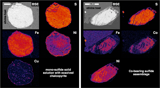
of major elements
in an Fe-rich (a)
and a Co-Ni-rich assemblage (b)
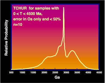
Preliminary results reveal that the lithosphere beneath the Lac de Gras area, Slave craton, Canada, contains at least two distinct sulfide assemblages, one with Ni-Fe mono-sulfide solid solution (mss) ± pentlandite (pn) ± chalcopyrite (cp), the other with Co-rich (up to 17.5 wt%) phases ± mss ± pn ± cp. The Re-Os systematics of about 20 mss-dominated inclusions have been analysed. One population gives plausible model ages (TCHUR), (0 < TCHUR < 4.5 Ga) testifying to undisturbed Re-Os isotope systematics. These sulfides may have formed during several melting episodes. The Re-Os model age spectrum shows two main peaks at 2.8 Ga and 3.3 Ga, ages that can be correlated with tectonothermal events in the area. Alternatively, the strong positive correlation shown by some of these inclusions can be interpreted as an isochron, yielding an age of 3.45 ± 0.25 Ga and an enriched initial 187Os/188Os of 0.1072 ± 0.0016. Recent Re addition is shown in some grains with low Os isotopic compositions combined with elevated Re/Os. This group may still yield meaningful Re-depletion ages (assumption: all Re has been lost during partial melting and any Re present is secondary), all of which are older than 3 Ga. The results suggest that the lithospheric mantle beneath the central part of the Slave Craton formed in a small time interval around 3-3.5 Ga ago.
Contact: Sonja Aulbach, Bill Griffin, Sue O'Reilly, Norm
Pearson
Funded by: ARC SPIRT, Kennecott Canada, GEMOC, MUPRF, IPRS, MUIPRA

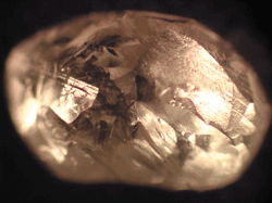
DIAMOND FINGERPRINTS - FOR SCIENCE AND PEACE
Diamonds are the mantle's time capsules they are strong
and chemically inert (until exposed to oxygen and high temperature),
and their mineral inclusions yield unique information on the composition
and history of the mantle where and when the diamonds formed.
But the nature of the medium from which the diamonds themselves
crystallised remains poorly understood. However, even gem-quality
diamonds contain minute quantities of trace elements, and crystal-chemical
considerations suggest that most of these must be in submicroscopic
inclusions, which might represent the diamond growth medium.
In the current chaotic situation in parts of Africa, control of
diamond deposits has become a potent factor in financing civil
wars; "conflict diamonds" from war-torn areas are smuggled
into countries with legimitate production, and laundered through
various channels until they appear in the open market. World-wide
efforts by DeBeers and other legitimate producers to assure that
they are not contributing to this situation demand a means of
identifying the source of individual stones. The trace-element
patterns of diamonds have been suggested as a possible means of
fingerprinting stones from different sources, and identifying
"conflict diamonds".
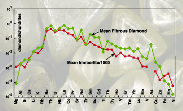
GEMOC's highly sensitive Agilent 7500 ICPMS, and New Wave Research laser-ablation microprobes, allow the determination of many elements down to parts per trillion. Quantitative calibration uses a synthetic oil as a primary standard and a synthetic glass as a secondary standard to extend the range of calibrated elements to more than sixty. Important trace elements, such as the rare earths, have now been measured in diamonds with sufficient precision to provide complete and smooth trace-element patterns. A comprehensive program of analysis is underway, designed both to evaluate the potential of "diamond fingerprinting" for forensic purposes, and to learn more about the origin of diamond. We have established a baseline for comparisons, by analysing "fibrous" or "coated" diamonds (several provided by Dr Oded Navon of the Hebrew University). Unlike most diamonds, these unusual stones have grown very rapidly in the kimberlite magma itself, during its ascent to the surface, and their fibrous structure has trapped samples of the growth medium. Stones from several localities show very similar trace-element patterns, and the average pattern is strikingly close to that of an average kimberlite magma (Fig. 1). The data confirm that these stones have included the kimberlite melt, and this pattern will serve as a template for the interpretation of data from other, more typical diamonds.
Contact: Simon Jackson, Rondi Davies, Bill Griffin; Funded by: ARC SPIRT, Kennecott Canada
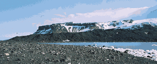
HEARD ISLAND: PIECING TOGETHER THE EVOLUTION OF THE KERGUELEN-HEARD PLATEAU
THE AUSTRALIAN TERRITORY of Heard and McDonald Islands lies in the windswept Southern Ocean, at 53 degrees south, 4500 km southwest of Perth. It is one of the few places where the enormous Kerguelen-Heard plateau breaks the water's surface (see front cover), the other being the Kerguelen Archipelago, 460 km to the north. Heard is dominated by the volcanic cone of Big Ben, rising from sea level to over 2700 m in less than 10 km. Big Ben and McDonald Island are Australia's only two active volcanoes the last major eruption of Big Ben took place in 1992, producing a flow on the SW slopes around 4.5 km long.
The Kerguelen-Heard Plateau began to form around 110 Ma ago over the southeast Indian ridge, with volcanism from the ridge and the Kerguelen Plume combining to produce the enormous volume of material that makes up the plateau. The plateau was split apart 43 Ma ago to form the submarine Broken Ridge plateau to the north, and the Kerguelen-Heard plateau, which remained over the hotspot on the Antarctic plate. Kerguelen has a large part of its volcanic history exposed at the surface the oldest lavas are around 40 million years old, and the most recent eruptions have taken place in the last 20 thousand years, at Mt Ross. Kerguelen is an unusual oceanic island in that granitic rocks are exposed at the surface rocks normally associated with continental settings. This has led workers to believe that the Kerguelen-Heard plateau may be neo-continental representing a transitional stage between oceanic and continental crust. An alternative view is that the plateau represents a small fragment of the Gondwana supercontinent, left isolated as Africa, India, Australia and Antarctica began to break apart around 130 million years ago.
The volcanic sequence exposed on Heard Island is considerably
younger than that on Kerguelen; the main vol canic landforms of
the island Big Ben and the Laurens Peninsula are thought
to be less than 1 million years old.
In the summer of 2000/2001 William Powell participated in the
ANARE expedition to Heard Island, with the aim of collecting mantle-derived
xenoliths to complement an ongoing GEMOC project in collaboration
with the Université Jean Monnet, which already has provided
insights into the lithospheric composition and structure of the
northern part of the Kergeulen-Heard plateau (Publications
175, 184).
The fieldwork was very successful and many xenoliths were collected from new localities: they were found in volcanic flows, and in basaltic boulders in moraine and sedimentary deposits. Xenolith types range from olivine-rich, coarse grained types to finer-grained xenoliths with relatively iron-rich olivines, and rare composite xenoliths of lherzolite with pyroxenite. Electron microprobe analysis of the constituent minerals will be used be used for thermometry, to infer the depth from which the xenoliths originated, and give an idea of the thickness of the crust beneath Heard Island. Trace element analyses using in situ laser ablation ICPMS will provide information on the melting and fluid-interaction history of the lower crust and upper mantle beneath the island, and Re-Os dating of sulphides in situ will be used to estimate the age of the underlying mantle, and help constrain the evolution of the Kerguelen-Heard plateau.
Contacts: Sue O'Reilly, Will Powell; Funded by: ASAC (AAD), MURG
COMPOSITION OF GROUNDWATERS: AN INSIGHT INTO SUB-SURFACE TEMPERATURES
HEAT FLOW is the driving force behind plate tectonics and it is ultimately responsible for much of the geology observed on the surface of the earth. Unfortunately, heat flow is relatively poorly determined across Australia, particularly when compared to North America and Europe. Heat flow is expressed as a function of geothermal gradient and thermal conductivity. Determining geothermal gradients requires a measurement or estimation of sub-surface temperature. Chemical geothermometers applied to groundwaters can give an insight into sub-surface temperatures. These are believed to be as accurate as temperatures obtained from conventional measurements in sedimentary basins.
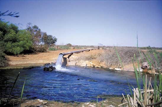
Although it covers approximately 20% of Australia, there are very few heat flow measurements in the Great Artesian Basin (GAB). A transect has been evaluated from Birdsville in Queensland, near the deepest part of the GAB, to Marree in South Australia, near the shallowest part of the basin (Fig. 1). Various silica and cation geothermometers have been applied to groundwater analyses obtained from samples that were collected from flowing artesian bores (Fig. 2) during fieldwork, and from government sources. Geotemperatures returned by the respective geothermometers have been compared and evaluated. The correlation with measured (emergence) temperature at the surface for many of the geothermometers suggests that water-rock equilibrium in the reservoir has been attained.
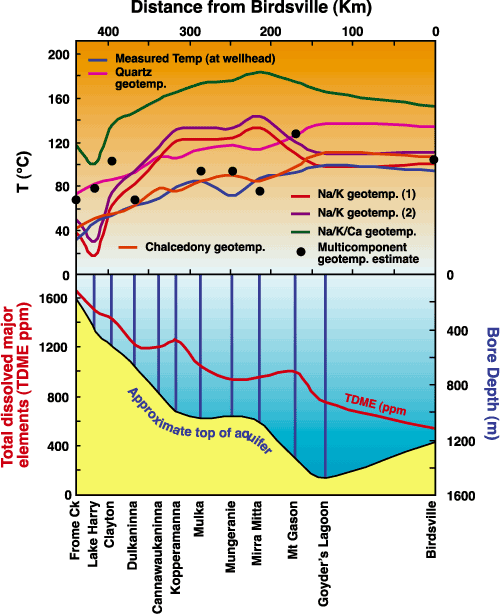
Current research is evaluating the applicability of multicomponent geotemperature estimates obtained through computer modelling of the groundwater. This type of geotemperature can be difficult to interpret, but it can offer useful information concerning the evolution of groundwaters in sedimentary basins.
Contact: Mark C. Pirlo, Sue O'Reilly
Project funded and supported by: Queen's Trust for Young Australians
Achievement Award, GEMOC National Key Centre, APA award, MUPR
Grant
BARCODING THE MANTLE: BASALTS AS PROBES TO EARTH'S GEODYNAMICS
PRIMITIVE BASALTS are our best geochemical probes (so far)
of the Earth's mantle below the lithosphere. The asthenosphere
redistributes heat by convection cells and plumes that change
in intensity in space and time. Basalts sample these reservoirs
at the time and place of melting.
At the simplest level, there are three main geochemical reservoirs
(Fig. 1): the convecting mantle or asthenosphere,
commonly considered to be the mantle source that yields the mid-ocean
ridge basalts and which may have its own heterogeneous domains;
plumes, which may have different geochemical signatures
depending on their ultimate origins; and the lithosphere
which is non-convecting and does not homogenise easily, and thus
carries a geochemical, thermal and chronological record of large-scale
tectonic events.
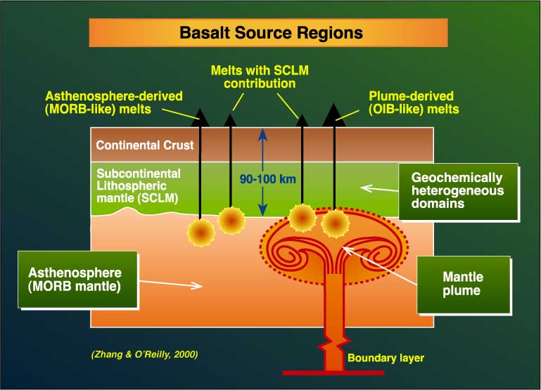
Figure 1: Source regions for primitive basalts
Eastern Australia is an ideal natural laboratory to assess the geochemical signatures of different types of basalt sources, their locations and the role of lithospheric mantle in modifying basalt composition. Primitive basalts extend for over 4,000 km along the east coast and across fundamentally different tectonic domains. They have erupted over a timespan from about 100 Ma to the present day and commonly contain mantle xenoliths that are direct samples of the rock types in the lithospheric mantle. Therefore integrated studies of basalts and xenoliths from the same locality can be used to unravel the contribution of the lithosphere to basalt compositions. Identifying specific types of lithosphere geochemical signatures in this way helps to recognise lithospheric contributions to basalts that lack xenoliths.
We have identified three major source regions contributing to the eastern Australian basalts (Publications # 133 and 219). Firstly, there are the distinctive geochemical signatures of the Pacific Ocean and Indian Ocean asthenospheric cells. The boundary between the "westerly" Indian and more "easterly" Pacific cells has moved eastward across the Australian continent over about the last 50 Ma so that young basalts in Queensland have an Indian cell signature. Secondly, there is the distinctive Australian plume (that has tracked southwards from central Queensland to the southern ocean over the last 45 Ma) and thirdly, there is the lithospheric component.
The different Australian basalt provinces also show different regional geochemical fingerprints that mirror the regional variations in composition that we see in xenoliths from lithospheric mantle. These lithospheric fingerprints are superimposed on the main geochemical signatures, which reflect the relative contribution from the asthenosphere and the Australian plume as the Australian plate has moved northwards. The geochemical characteristics of each lithospheric domain are in turn the combined imprint of different episodes of anatexis and fluid fluxes (metasomatism) of different origins (including primitive mantle fluids and subduction-derived fluids), related to different tectonic events through time. Each major episode appears to have resulted in distinctive geochemical signatures and a given lithospheric domain may record multiple events.
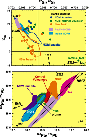
Geochemical fields for Nd-Sr and Pb systems are shown (Fig. 2) for basalts from different provinces. These contrasts in Sr-Nd-Pb isotopic trends reflect not only the influence of the Pacific- and Indian-asthenospheric mantle convection cells, but also the principal regional geochemical heterogeneity of the lithospheric mantle domains (EM1 for New South Wales and EM2 for North Queensland). This heterogeneity appears to be fractal and detailed work on basalts within the North Queensland Province has identified different source contributions for younger and older basalts. The older ones (44-25 Ma) have isotopic signatures requiring contributions from the Australian plume and an EM2-type lithospheric mantle while the Sr-Nd-Pb isotopic trends for younger North Queensland basalts can be explained by mixing of Indian asthenosphere and EM2-type lithospheric mantle sources derived from late Paleozoic regional orogenesis (Publication #219). At a more detailed level, the high U/Pb ratios (negatively correlated with Pb isotopic ratio) shown by some highly undersaturated North Queensland basalts may have been generated from amphibole- and apatite-bearing lithospheric mantle affected by young (< 40 Ma) metasomatism caused by the early Tertiary subduction of the Phoenix-Pacific plate under that region.
Figure 3 gives a summary of this
work in progress and emphasises that primitive continental basalt
compositions may reflect both mantle composition at the source
of melting and additions from the lithospheric mantle. Components
such as EM1, EM2, HIMU may reside in the continental lithospheric
mantle and reflect metasomatism due to specific tectonic events.
Mapping mantle geochemical reservoirs in timeslices can
provide constraints for the geodynamic evolution of continental
regions.
Contact: Sue O'Reilly, Ming Zhang
Funded by: ARC, Macquarie University, ACILP (AusAID)
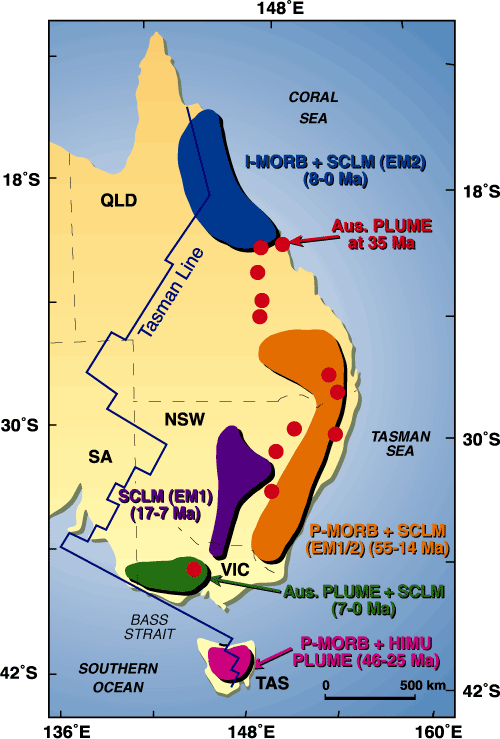
Figure 3: Barcoding of the eastern Australian mantle domains.
SCLM = subcontinental lithospheric mantle; geochemical abbreviations
are explained in Publication
# 219.
![]()
THE SLAVE CRATON (CANADA) IN DEEP ANALYSIS
THE SLAVE PROVINCE in Canada is one of GEMOC's natural laboratories, where we can integrate geochemical, tectonic and geophysical data to map major lithospheric domains. This project is part of a SPIRT grant with Kennecott Canada. The Slave craton is a small Archean nucleus within the larger North American craton. Xenoliths and heavy mineral concentrates have been used to map the composition, structure and thermal state of the lithospheric mantle beneath the Lac de Gras area on the craton. This analysis revealed a distinct two-layered lithosphere beneath the Slave craton: a shallow ultradepleted layer and a deeper less depleted layer. The two layers are separated by a sharp boundary at 140-150 km depth (Fig 1). Griffin et al. (1999) interpreted the lower layer as plume material accreted from the lower mantle. This interpretation is consistent with the presence of abundant lower-mantle inclusions in diamonds from the region (Davies et al., 1999).
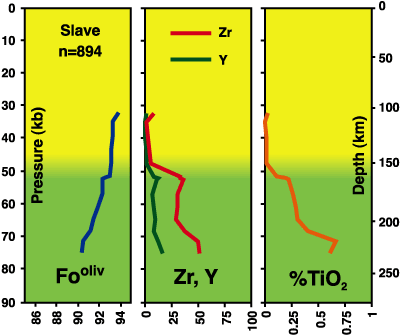
Figure 1: The layered structure of the Slave lithospheric
mantle shown by key geochemical indicators. Note the ultra-depleted
composition of the upper layer down to about 150 km.
Gravity data have been enhanced to map large-scale structures on the Slave craton. A map of the gravity data upward continued to 100 km (Fig. 2) shows long wavelength negative Bouguer anomalies on the central part of the craton, correlating with the major kimberlite fields. The northern part of the craton is characterised by relative positive anomalies, which probably reflect the head of the MacKenzie plume that produced major dyke swarms across the craton. Maps of vertical and horizontal derivatives of the Bouguer anomalies highlight NS-oriented structures (eg the eastern and western margins of the craton), as well as near EW-oriented structures (eg Great Slave Shear Zone).
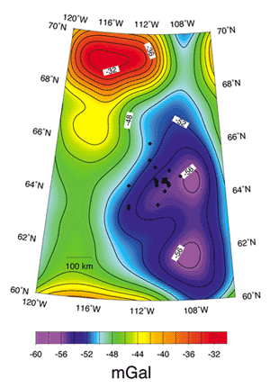
Figure 2: Colour contour map of the Bouguer gravity anomalies on the Slave craton, upward continued at 100 km. The filter applied to the gravity data in this case attenuates shallow features and enhances long wavelength or regional features > 100 km. Note that most of the diamond-bearing kim berlites (black diamonds) coincide with located an area of large negative Bouguer anomalies (less dense lithosphere).
Gravity and topographic data have been inverted to estimate
the flexural strength or effective elastic thickness (Te)
of the lithosphere of the Slave craton. The regional Te
map shows variations from 14 km to 66 km (Fig.
3). The northern part of the craton is characterised by a
relatively weak lithosphere (Te < 25 km) surrounded
by stronger lithosphere, the strongest being in the eastern part
of the craton (Te > 56 km). A zone of low Te
(oriented N-S) defines the western edge of the strong lithosphere
to the east of the craton. This feature may map the deep extension
of the suture between the ancient continental block (up to 4 Ga
old) making up the western part of the craton, and the younger
(2.7-2.9 Ga) accreted terranes that make up the eastern part.
The zone of low Te gradient corresponds to the area where
long-period magnetotelluric studies have defined a strongly conductive
upper mantle (Jones et al., Geology, 2001). At this stage of the
work, the reasons for the correlation between Te and the
conductive upper mantle are not obvious. The diamond fields on
this part of the Slave Province are concentrated within the zone
of low Te and anomalous mantle conductivity. This zone
appears to be geochemically and geophysically anomalous and to
represent a major lithospheric discontinuity on the Slave craton.
Contact: Yvette Poudjom Djomani, Bill Griffin, Sue O'Reilly,
Norm Pearson; Funded by: ARC SPIRT, Kennecott Canada Inc. and
Macquarie University
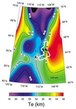
Figure 3: Colour contour map of the Effective Elastic Thickness (Te) of the lithosphere on the Slave craton showing a zone of low Te gradient (oriented N-S), defining the western edge of the strong lithosphere (Te > 56 km) to the east of the craton. The white polygon outlines the area where magnetotelluric studies have defined a strongly conductive upper mantle
THE NEW GEM IN GEMOC - THE GJ-1 ZIRCON STANDARD
| The large volume of laser-ablation ICPMS (LAM-ICPMS) U-Pb dating of zircons carried out at GEMOC during 2000 emphasized the need for a reliable "standard" zircon. The dating method depends on the regular analysis of a zircon with known lead-isotope composition and U/Pb ratio, to correct for elemental fractionation in the laser and mass bias in the ICPMS. Since each analysis uses up a small volume of zircon, a standard tends to disappear with time. A standard needs to be very homogeneous in isotopic composition, and to contain enough U and Pb that good counting statistics can be attained during analysis. Much of the dating done in the world today, either by ion microprobe or LAM-ICPMS, relies on a small number of standards, all of them in very short supply. In 2000 GEMOC approached Jerry Yakoumelos of G & J The Gem Merchants, of Sydney. The firm had earlier helped Jingfeng Guo with sapphire material for his PhD thesis work at Macquarie, and Jerry responded to our plea for a "big, old, homogeneous, high-uranium zircon" by producing a large bag of gem-quality rough zircons 1-2 cm across, colored from pale yellow through red to chocolate brown. Their exact locality is lost in the mists, but they probably are derived from granulite-facies pegmatites in E. Africa. Testing so far indicates that they are very homogeneous isotopically, range from 100-250 ppm U, and have excellent laser-ablation characteristics. Several grains have been dated using conventional high-precision mass spectrometric techniques by Dr F. Corfu at the University of Oslo; they showed little variation and gave an age of 608.5 Ma. All indications are that the "GJ-1" zircon will be a very useful standard. If further tests confirm this, GEMOC will distribute the standard to other laboratories. |  |
SUPERDEEP DIAMONDS
TO CHARACTERISE the deep Earth's physical properties and composition we rely on seismologists and experimental petrologists to provide theoretical models and data from experiments. Direct sampling of material from more than 400 kilometres below the earth's surface to test and build on such models has not been feasible.
That is, until recent years when it was found that rare diamonds contain assemblages of mineral inclusions that require pressures and temperatures corresponding to at least 670 km below the Earth's surface.
As diamonds grow, they trap minerals from the surrounding rocks. Provided that no cracks form in the diamonds later, these minerals remain inert to later processes that may modify the mantle. Diamond inclusions thus allow us to study the composition of ancient mantle environments, including the age of entrapment, and to speculate on processes in oldest parts of the Earth. In addition, diamond inclusion data can be directly used as a tool in diamond exploration
Most diamonds have formed at depths of 150-200 km in ancient thickened continental roots. Diamonds with deep mantle mineral inclusions have been recognised from only about eleven localities worldwide. At GEMOC we have had the opportunity to study diamonds and their inclusions from two of these regions, the Juina alluvial deposit in Mato Grosso, Brazil and kimberlites at Lac de Gras in the Northwest Territories, Canada.
Mineral assemblages in these superdeep diamonds correspond to formation depths of the seismically defined transition zone between about 400 and 670 km, the base of which defines the UpperLower mantle boundary. The transition zone marks the transformation of upper mantle silicate phases with orthorhombic structures, to denser spinel and perovskite structured phases. Seismic models suggest that the mantle is dominantly peridotitic in composition, and that these structural transformations in olivine define global seismic discontinuities at 410 and 670 km.
Inclusions in diamonds from Juina, Brazil are essentially all from the lower mantle (ca 670 km) and have compositions consistent with peridotitic host rocks. In addition to the known superdeep inclusion types, we found some new phases including Ti-Fe rich chrome-spinel and Mn-ilmenite.
About 10% of diamonds from Lac de Gras contain superdeep phases, and these also have peridotitic compositions. Interestingly, most of the lithospheric diamonds from the same deposits are from the eclogitic paragenesis. However, there are also a few eclogitic diamonds that contain majoritic garnets, suggesting that some formed below the cratonic roots, in the upper transition zone. It appears that eclogitic diamonds also are common at other superdeep diamond localities around the world, although in general eclogitic diamonds only comprise a small fraction of most deposits.
The link between eclogitic diamonds sourced from the upper mantle through the transition zone, and superdeep diamonds with peridotitic compositions from below the Upper Lower mantle boundary, provides new insights into the composition and structure of the mantle and the formation of diamond, with many parallels to the megalith model of Ringwood (1991).
Contact: Rondi Davies, Bill Griffin
Funded by: GEMOC.
A KEY PALAEOMAGNETIC POLE FOR THE EARLY PERMIAN FOR AUSTRALIA AND GONDWANA
PALAEOGEOGRAPHIC RECONSTRUCTIONS for pre-Mesozoic times rely heavily on well-defined apparent polar wander paths from each of the continental blocks involved in the reconstructions. The tightness of the fit of the southern continents into the supercontinent of Gondwana during the Palaeozoic, and the degree of subsequent intraplate deformation in Africa, can only be tested with precise, well-dated, essentially coeval, palaeomagnetic poles from its constituent continents. Similarly, differing hypotheses regarding the relative configuration of Gondwana and Laurasia within Pangaea in the Late Palaeozoic require comparison of well-defined coeval poles from the two constituent supercontinents. Unfortunately, high quality palaeomagnetic data for the Late Palaeozoic have been scarce for the Gondwanan continents. Over the last decade, a few relatively high quality palaeomagnetic poles for Permian rocks of Africa have been reported, with no similar quality poles from other Gondwana components. Recent work at GEMOC has provided reliable, precisely defined and well-dated Early Permian (286 ± 5 Ma) palaeomagnetic poles for Australia from the Mount Leyshon Igneous Complex (MLIC) and the Tuckers Igneous Complex (TIC) that will enable such comparisons to be made.
The characteristic remanence carried by the intrusive phases and by locally remagnetised contact metamorphosed host rocks has ubiquitous reversed polarity, consistent with acquisition during the Permo-Carboniferous (Kiaman) Reverse Superchron. The corresponding palaeopoles confirm that Australia occupied high latitudes in the Early Permian. The pole positions are: MLIC: Lat = 43°S, Long = 137°E (dp = 6.0°, dm = 6.4°; Q = 6); TIC: Lat = 49°S, Long = 142°E (dp = 10.3°, dm = 11.4°; Q = 6). The primary nature of the Early Permian palaeomagnetic signature is established by full-baked contact aureole tests at both localities.
The new poles are more consistent with Pangaea B type reconstructions of Gondwana and Laurasia than with the Pangaea A2 configuration. Systematic differences between approximately coeval poles from Africa, South America and Australia, require a tighter fit than is found in standard Gondwana reconstructions. This suggests that some attenuation of continental margins, not accounted for in the reconstructions, has taken place during the breakup of Gondwana. If stretching of continental margins during breakup of supercontinents is a general phenomenon, it may help to resolve the longstanding controversy regarding Pangaea reconstructions.
Contact: Mark Lackie, Dave Clark
Funded by: Macquarie University, AMIRA
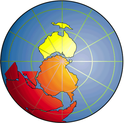
The position of Gondwana in the Permian (~285 Ma), based on the MLIC palaeomagnetic pole.
SORTING OUT THE MANTLE: IN SITU MEASUREMENT OF RE-OS ISOTOPES IN MANTLE SULFIDES BY LAM-MC-ICPMS
THE IN SITU RE-OS ISOTOPE analysis of mantle sulfides was developed at GEMOC during 1999-2000, and has rapidly become the most powerful method available for dating mantle events the time framework essential to 4-D lithosphere mapping. The method, which uses GEMOC's multi-collector ICPMS laser microprobe (LAM-MC-ICPMS) has a great advantage over conventional Re-Os analysis because it analyses single sulfide grains, and preserves the microstructural context necessary for interpretation of the analytical data. Another advantage is that each analysis takes a few minutes, without the need for the difficult and time-consuming separation of the sulfides and micro-chemical extraction of Os.
Using LAM-ICPMS analyses of sulfides in mantle-derived peridotites, Alard et al. (2000; see Research Highlights in 1999 Annual Report) showed that sulfides enclosed in primary silicate minerals typically have high Os and Ir contents (> 100,000 x PM) and low Pd/Ir ratios (Pd/Ir < 0.5), whereas interstitial sulfides have low Os and Ir contents and high Pd/Ir ratios (up to 1000). Both types of sulfide commonly occur in the same sample. The silicate-enclosed sulfides are thought to represent the residues of partial melting, and the intersitial sulfides the crystallisation products of sulfide-bearing metasomatic fluids. During 2000, the analysis of Os isotopes in these two sorts of sulfides in xenoliths from ancient and young lithospheric mantle has shown its usefulness in understanding the complexity of mantle rocks.
The best precision for the in situ Os isotope technique is obtained from sulfides with > 40 ppm Os and > 100 µm in size. Such sulfides are common as inclusions in macrocrystic olivine in kimberlites (e.g. Udachnaya pipe, Siberian craton, Russia; Lac de Gras, Slave craton, Canada; see Research Highlight). In situ LAM-ICPMS showed that the sulfides from Udachnaya can have very high PGE contents (up to 900 ppm) and very low Pd/Ir (0.0002-0.0093). 187Os/188Os ratios of these sulfides range between 0.1033 ± 0.0002 and 0.1118 ± 0.0013, while the low 187Re/188Os ratios (0.006 to 0.081) are consistent with their low Pd/Ir. The unradiogenic Os isotopic ratios require that these sulfides have evolved in a low Re/Os environment since roughly 3 Ga ago. The in situ results are in good agreement with data for diamond-enclosed sulfides from the same pipe (Pearson et al., 1999) and have demonstrated the reliability of the in situ method relative to the already established micro-chemistry method.
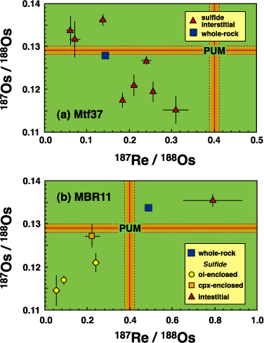
The results from two spinel lherzolites from the Massif Central, France highlight the power of the in situ technique in understanding processes within the mantle. A low-temperature spinel lherzolite from the Montferrier alkali basalt (Sample Mtf37; Languedoc, southern France) contains interstitial sulfides that produce an inverse correlation between 187Os/188Os and Re/Os ratio (Fig. 1a). The low 187Os/188Os of some of these sulfides yields TRD ages down to 1.8 Ga. The relationship between sulfide and whole-rock data indicates that the whole-rock Os isotopic composition represents the mixing of Proterozoic components and younger radiogenic Os. The negative 187Os/188Os Re/Os correlation suggests that the radiogenic Os, but not Re, has been transported from a high Re/Os reservoir via a metasomatic fluid. A coarse, granular spinel-lherzolite (MBR11) from Mont Briancon, Massif Central, France has a whole-rock Os isotopic composition and 187Re/188Os ratio more radiogenic than the primitive mantle; the usual interpretation would call upon host lava contamination. However, in situ Os-isotope data show that silicate-enclosed sulfides have a wide range of 187Os/188Os, correlated with 187Re/188Os. The analysed interstitial sulfide shows an even more radiogenic Os signature and higher Re/Os ratio (Fig. 1b). In both of these samples it is clear that the whole-rock Re-Os signature reflects a mixing of several sulfide populations, and that Os is mobile within the lithosphere, contrary to general belief.
The work carried out so far shows that the LAM-MC-ICPMS technique can provide Os-isotope analyses of individual sulfide grains with precision and accuracy comparable to whole-rock analyses using Carius tube digestion and N-TIMS analysis, provided the grains contain > 40 ppm Os. Grains with lower Os contents yield data with lower precision, but the analyses of Massif Central peridotites demonstrate that these data still provide valuable information on the movement of Os within the lithosphere. Our analyses of sulfides in peridotite xenoliths confirm that sulfides enclosed in silicates preserve significantly less radiogenic Os isotopic compositions than interstitial sulfides. Whole-rock Os-isotope compositions will generally reflect the proportions of these different types of sulfides, and this casts doubt on the significance of many published "depletion ages". However, analysis of sulfides enclosed in primary silicates can produce more realistic estimates of depletion ages in the lithospheric mantle. These data will allow more detailed correlation between events in the mantle and the overlying crust, and a better understanding of Earth's dynamics.
Contact: Bill Griffin, Norm Pearson, Sue O'Reilly
Funded by: ARC, GEMOC, IPRS, MUIPRA, MUPRF, MURG
PARTITION COEFFICIENTS-ESSENTIAL INGREDIENTS FOR MODELLING THE GEOCHEMICAL EVOLUTION OF THE CRUST-MANTLE SYSTEM.
TRACE ELEMENT PARTITION COEFFICIENTS (D) for up to 13 REE, Nb, Ta, Zr, Hf, Sr and Y have been determined by SIMS analysis of 7 garnets, 4 clinopyroxenes, 1 orthopyroxene and 1 phlogopite crystallized from an undoped basanite and a lightly doped (200 ppm Nb, Ta and Hf) quartz tholeiite. Experiments were conducted at 2-7.5 GPa, achieving near-liquidus crystallization at relatively low temperatures of 1080-1200 °C under strongly hydrous conditions (5-27% wt. added water). Garnet and pyroxene DREE show a parabolic pattern when plotted against ionic radius, and conform closely to the lattice strain model of Blundy and Wood. Comparison, at constant pressure, between hydrous and anhydrous values of the strain-free partition coefficient (D0) for the large cation sites of garnet and clinopyroxene reveals the relative importance of temperature and melt water content on partitioning. In the case of garnet the effect of lower temperature, which serves to increase D0, and higher water content, which serves to decrease D0, counteract each other to the extent that water has little effect on garnet-melt D0 values. In contrast, the effect of water on clinopyroxene-melt D0 overwhelms the effect of temperature, so that D0 is significantly lower under hydrous conditions. For both minerals, however, the lower temperature of the hydrous experiments tends to tighten the partitioning parabolas, increasing fractionation of light from heavy REE compared to anhydrous experiments.
Three sets of near-liquidus clinopyroxene-garnet two-mineral D values increase the range of published experimental determinations, but show significant differences from natural two-mineral Ds determined for subsolidus mineral pairs. Similar behaviour is observed for the first experimental data for orthopyroxene-clinopyroxene two-mineral Ds when compared with natural data. These differences are in large part a consequence of the subsolidus equilibration temperatures and compositions of natural mineral pairs. Great care should therefore be taken when using natural mineral-mineral partition coefficients to interpret magmatic processes.
The new data for strongly hydrous compositions suggest that fractionation of Zr-Hf-Sm by garnet decreases with increasing depth. Thus melts leaving a garnet-dominated residuum at depths of about 200 km or greater may preserve source Zr/Hf and Hf/Sm. This contrasts with melting at shallower depths where both garnet and clinopyroxene will cause Zr-Hf-Sm fractionation. Also, at shallower depths clinopyroxene-dominated fractionation may produce a positive Sr spike in melts from spinel lherzolite, but for garnet lherzolite melting no Sr spike will result. Conversely, clinopyroxene megacrysts with negative Sr spikes may crystallize from magmas without anomalous Sr contents when plotted on mantle compatibility diagrams. Because the characteristics of strongly hydrous silicate melt and solute-rich aqueous fluid converge at high pressure, the hydrous data presented here are particularly pertinent to modelling processes in subduction zones, where aqueous fluids may have an important metasomatic role.
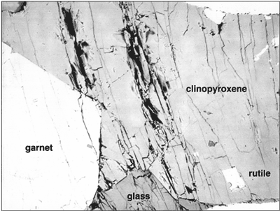
Rutile-a minor mineral with a big geochemical punch
Mass balance calculations involving the Earth's crust and estimated compositions for the primitive (Chondritic) and depleted mantle produce several conundrums; one is that there appears to be less Nb and Ta in the continental crust than is required, and that the continental crust has a significantly lower Nb/Ta ratio than the mantle. Rutile has been proposed as a key to explaining the "missing" Nb and Ta in the crust, by sequestering these elements in the subducted oceanic crust as this transforms to rutile-bearing eclogite, loses a melt or fluid component and travels into the lower mantle. A detailed study of the partitioning of Nb, Ta, Zr and Hf between rutile and a range of melts (basalt through to rhyolite and carbonatite) and aqueous fluid at high pressure and temperature (1.5-3.5 Gpa and 900-1050 °C) has revealed that rutile consistently favours Ta over Nb relative to melt or fluid. Thus these results limit the role proposed for rutile to equilibration with a highly silicic melt at lower temperature (800 °C), where other researchers have shown that rutile has a higher Nb/Ta than the coexisting melt.
Carbonatite-a popular mantle metasomatic agent
Trace element-rich carbonatite generated in the mantle has often been called upon as a metasomatic agent, modifying the trace element composition of affected mantle domains. However although it has been demonstrated that mantle derivation of carbonatites is possible, it has not been shown that such melts will have the appropriate trace element composition. Such testing requires knowledge of partition coefficients between relevant silicate minerals and carbonatitic melts.
The GEMOC laser-ablation ICPMS microprobe was used to analyse concentrations of K, Rb, Cs, Sr, Ba, Ti, Zr, Hf, Nb, La, Ce, Sm, Ho, Yb and Lu in experimentally produced garnet, clinopyroxene, amphibole and magnesiocarbonatitic melt. The experiment was conducted at 1050 °C and 2.5 GPa on a synthetic composition designed to simulate natural peridotite melting. Crystal/melt partition coefficients determined from the experiment were used to calculate minor and trace element concentrations in a hypothetical carbonatitic melt equilibrated with a garnet-bearing amphibole lherzolite of primitive mantle composition. The resulting melt is strongly enriched in alkaline earths and rare earths relative to high field strength elements and alkalis, and plots within the compositional range of natural carbonatites. However, the fractionation of alkaline earths and REE from alkalis and HFSE is usually larger in natural carbonatites than in the calculated composition. The absolute concentrations of many incompatible elements are also much larger in some natural carbonatites. Because of these features, processes in addition to peridotite melting (such as crystal fractionation, wall rock reactions, and variations in source chemistry) are needed to fully account for the minor and trace element characteristics of carbonatites.
Contact: T. Green, J. Adam
Funded by: MURG and ARC
Basalt at 4.0 Gpa, 1100 °C with 15% added water.
![]()