 GEMOC ARC National Key Centre
Research Highlights
- Where has the mantle under Australia been?
- Diamonds from the deep and shallow
- Apatite: a sensative indicator of crystallisation environment
- Other world: deep space 2
- Detecting lithosphere-scale structures: Siberian platform
- From the micro to the macro or: has the earth changed?
- Continental fragments within an oceanic plateau? The Agulhas Plateau, SW Indian Ocean
- Where has Australia been?
- Trace elements in the carbon of your choice by LAM-ICP-MS
- Granites hot and cold
(for Numbered publications seeAppendix 2)
WHERE HAS THE MANTLE UNDER AUSTRALIA BEEN?
The global-scale mantle convection cells in the asthenosphere are not geochemically homogeneous. The heterogeneity is most prominently reflected in the isotopic compositions (Pb-Sr-Nd) of the mid-ocean ridge basalts (MORB) that are direct partial melts from the underlying asthenosphere. Of particular relevance to Australia's geodynamic evolution from about 100 million years, is the distinctive geochemical signatures of the asthenosphere beneath the Pacific Ocean (Pacific MORB) and Indian Ocean (Indian MORB). Therefore, delineation of the boundary between the two distinct mantle reservoirs and any change in that boundary with time provides information about the patterns of global-scale asthenospheric mantle convection from the base of the lithosphere to the core-mantle boundary. This information also allows us to track global-scale mantle chemical reservoirs such as the distinctive Gondwana lithospheric mantle and hence better understand the geodynamic evolution of the Australian continent from the time of Gondwana dispersal.
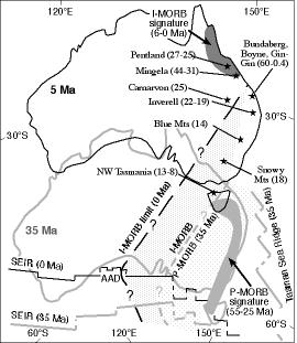 |
Shaded fields show distribution of the Australian basalts with Pacific-MORB and Indian-MORB geochemical signatures at 35 Ma and 5 Ma. Solid stars represent present-day locations of basalts. Numbers in brackets are ages of the basalts in Ma. |
Pb-Sr-Nd isotope data for Cenozoic basalts in eastern Australia indicate that Pacific-MORB type mantle isotopic signatures characterise the lava-field basalts (55-14 Ma) in southeastern Australia, whereas Indian-MORB type mantle isotopic signatures characterise younger basalts (6-0 Ma) from northeastern Australia. This discovery helps to constrain the changing locus of major asthenospheric mantle convection cells represented by the Pacific and Indian MORB sources during and following the breakup of the eastern part of Gondwana, and locates, for the first time, the locus of the boundary of these convection cells beneath the Australian continent. These new data also indicate that the Indian-MORB source is a long-term asthenospheric reservoir beneath most of the Gondwana lithosphere and that the westward migration of the Pacific MORB source may have been associated with the Tasman Sea opening (ca 85-60 Ma) along a broad front southeast of the Australian continent.
Publication: 133 (Appendix 2)
Contact: Ming Zhang and Sue O'Reilly
Funded by: ARC, Macquarie University, ACILP
Part of GEMOC's Lithosphere Mapping and Geotectonics strands.
DIAMONDS FROM THE DEEP AND SHALLOW
DIAMONDS from kimberlites recently discovered in the Slave Craton (Canada) were compared with alluvial diamonds from eastern Australia using mineral inclusions, morphological characteristics, carbon isotopes, nitrogen contents and nitrogen aggregation states of the diamonds. Diamonds from the DO-27 kimberlite pipe (Canada), largely contrast with the characteristics of those from eastern Australia, and have provided new information about the mantle from the Lac de Gras region in the central Slave Craton.
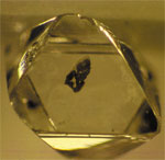
Figure 1. Octahedral diamond with peridotitic inclusion, Slave Craton, Canada |
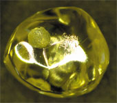
Figure 2. Dodecahedral diamond with resorbed, glossy surfaces, Bingara, eastern Australia. |
The syngenetic mineral inclusions encased in diamond preserve pristine samples of the ancient cratonic mantle from the time of diamond crystallisation. The combined inclusion and diamond studies show that about half of the diamonds from the DO-27 kimberlite formed in an eclogitic environment, 35% in peridotite environments and the remaining 15% are from the "super-deep" paragenesis, recognised from only eleven diamond localities worldwide.
Super-deep minerals include ferropericlase ((Mg, Fe)O) and Mg, Fe-perovskite ((Mg, Fe)SiO3) with inferred formation conditions in excess of 1000°C and 200 kbars, equivalent to lower mantle depths of more than 650 km. The super-deep diamonds may be evidence for the activity of ancient deep plumes in the construction of the Slave Craton. A parallel GEMOC study of xenoliths and heavy mineral concentrates from kimberlites across the central region of the Slave Craton found that the mantle lithosphere has a two-layered structure. The lower layer, (about 150 to 220 km), may host the super-deep and eclogitic assemblages, while the peridotitic diamonds may derive from the higher levels with more depleted and older mantle.
The diamonds from the Slave Craton contrast in morphology with those from eastern Australia (see the octahedral diamond from the Slave Craton and the dodecahedral diamond with resorbed and glossy surfaces. Their low nitrogen contents do not allow cathodoluminescece imaging as do the eastern Australian diamonds (Fig. 3). The fundamental differences between the diamonds of these two occurrences have led to our conclusions that some of the Canadian diamonds originated in the lower mantle, while some eastern Australian ones formed at shallow levels, probably in a subduction environment.
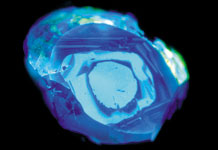 |
Figure 3. A cathodoluminescence image of a diamond from Bingara, eastern Australia, with high nitrogen content. |
Contact: Rondi Davies, Bill Griffin, Sue O'Reilly
Partly funded by Rio Tinto.
Part of GEMOC's Lithosphere Mapping and Metallogenesis strands.
APATITE: A SENSITIVE INDICATOR OF CRYSTALLISATION ENVIRONMENT
Apatite is a ubiquitous accessory mineral in magmatic, metamorphic and sedimentary rocks.
It is found in mafic to felsic rocks, in carbonatites and in many mineralised environments including magmatic iron-ore deposits. Apatite may concentrate a high proportion of the whole-rock REE, Y, Sr, U, Th and thus, apatite is a sensitive recorder of the trace element chemistry of the rock at the time of its crystallisation. Where crystallisation has taken place over an extended time, differences between generations of apatite and/or compositional zoning within individual grains, record the evolution of the chemical environment.
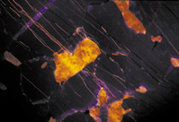 |
Figure 1. Cathodoluminesence image of an apatite with veinlets of calcite from Palabora carbonatite complex, South Africa. |
The GEMOC laser-ablation ICPMS microprobe has allowed analysis of about 30 trace elements (including REE, Y, Sr, U, Th, Pb, Fe, Mn) from 30-50 µm spots on a single apatite crystal. In a broad survey of apatite variability, representative samples have been analysed from granites (from Australia and Norway), larvikites and pegmatites (Norway), dolerites (Ukraine), as well as from less common rock types such as carbonatites (Fen, Norway; Palabora, S. Africa; Kovdor, Russia; Mud Tank, Australia), jacupirangite (Kodal, Norway), and iron ore deposits (Kiruna, Sweden and Durango, Mexico). Trace-element signatures specific for apatite of different origins have been defined, and show that the distribution of trace elements, especially REE, Y, Mn and Th in apatite depends not only on the mineral structure, but on the abundance of these trace elements and the chemical characteristics of the melt or fluid from which the apatite crystallised.
Particular attention has been paid to the study of primary magmatic apatites from granitoid rocks, to determine how the chemistry of this mineral reflects granite fractionation and composition, and to test whether apatite composition can be used to characterise granite suites related to Cu-Au mineralisation. This study focused on the Proterozoic granite suites of the Mount Isa Inlier, using the extensive AGSO granite collection. Preliminary results suggest that the variation in trace element concentrations within apatites is directly correlated with whole rock parameters such as the SiO2 and alkali contents and the aluminium saturation index, as well as fO2 and the presence of other accessory phases. The trace element patterns of apatite in the highly fractionated and highly oxidised granitoids related to Cu-Au mineralisation were found to be distinct from those of apatites in the less fractionated, less oxidised barren granites (Figure 2). Apatite turns out to be a highly sensitive indicator of the mineralisation potential of a granite body or suite, and is a potentially useful exploration tool.
| Figure 2. Apatite trace element patterns from Mount Isa granitoids. | 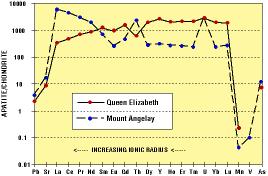 |
Contact: E. Belousova, W. L. Griffin, S. Y. O'Reilly.
Funded by: APA, BHP, Macquarie University
Part of GEMOC's Metallogenesis and Crustal Generation strands.
With an on time launch on the 3rd of January, 1999, GEMOC started its first excursion to another planet, Mars. Mars is near the end of its lithospheric evolution and represents an end-member in lithospheric studies. It is also an extreme remote environment, and technology developed for remote studies on Mars may find application in exploration in remote areas of Earth's continents. Paul Morgan is one of nine scientists to lead the science data acquisition for DS-2, the first NASA mission to penetrate the surface of another planet. Deep Space 2, or DS-2, is the second in a series of missions jointly conceived by NASA and the Jet Propulsion Laboratory under the umbrella of the New Millennium Program with the program motto, "Faster, Cheaper, Better." This concept is something for which many organisations are striving as we enter the third millennium: Faster ? less time between conception and implementation; Cheaper ? use existing resources and knowledge wherever possible; Better ? focus on achieving the goal not the process. DS-2 admirably meets these criteria.
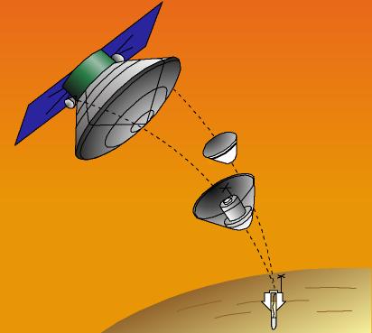 Figure 1. Separation of DS-2 aeroshells from the Mars Polar Lander spacecraft.
The DS-2 mission is two microprobes that are flying piggyback on another spacecraft, the Mars Polar Lander. The microprobes are small enough (basketball-size) and light enough (about 2 kg each) to use payload and space that would have been otherwise wasted on the Delta II launch vehicle (the ultimate cheap launch - a free ride). They will be released just prior to the insertion of the parent vehicle into Mars orbit and will free fall to the surface. The microprobes are enclosed in thin ceramic aeroshells that protect the probes from heat generated during entry through the atmosphere and orient the probes to impact the surface nose first. On impact the aeroshells will shatter, and the probes will penetrate the Mars surface.
The principle scientific goal of the probes is to detect volatile compounds in the Mars soil. Cooling from the heat of entry and penetration of the probes will be used to determine the thermal properties of the Mars soil, a parameter that is sensitive to the presence of any ice or water. In addition, a small drill in the probe will collect a small sample of the soil, heat it, and pass any evolved gas in front of a laser to detect water or carbon dioxide.
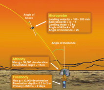 Figure 2. DS-2 microprobe parameters.
Surface morphology indicates that Mars had abundant surface water at some time in the past, but its current atmosphere is so thin and so cold that modern surface water cannot exist for more than a short time. DS-2 will be the first exploration into the subsurface for the missing water on Mars.
Contact: Paul Morgan Funded by: NASA
DETECTING LITHOSPHERE-SCALE STRUCTURES: SIBERIAN PLATFORM
The Siberian platform is one of GEMOC's key natural laboratories - a place where mantle petrology, geophysics and crustal terranes can be integrated to study the relationships between crustal and mantle processes, and the geophysical signatures of both. A formal collaboration with VSEGEI (St. Petersburg) brought Dr Yuriy Erincheck to Sydney to work with GEMOC Postdoctoral Fellow Yvette Poudjom Djomani and GEMOC Associate Lev Natapov on the analysis of geophysical data from an area of 1.4 million km2 in the NE part of the platform (Fig. 1, and front cover).
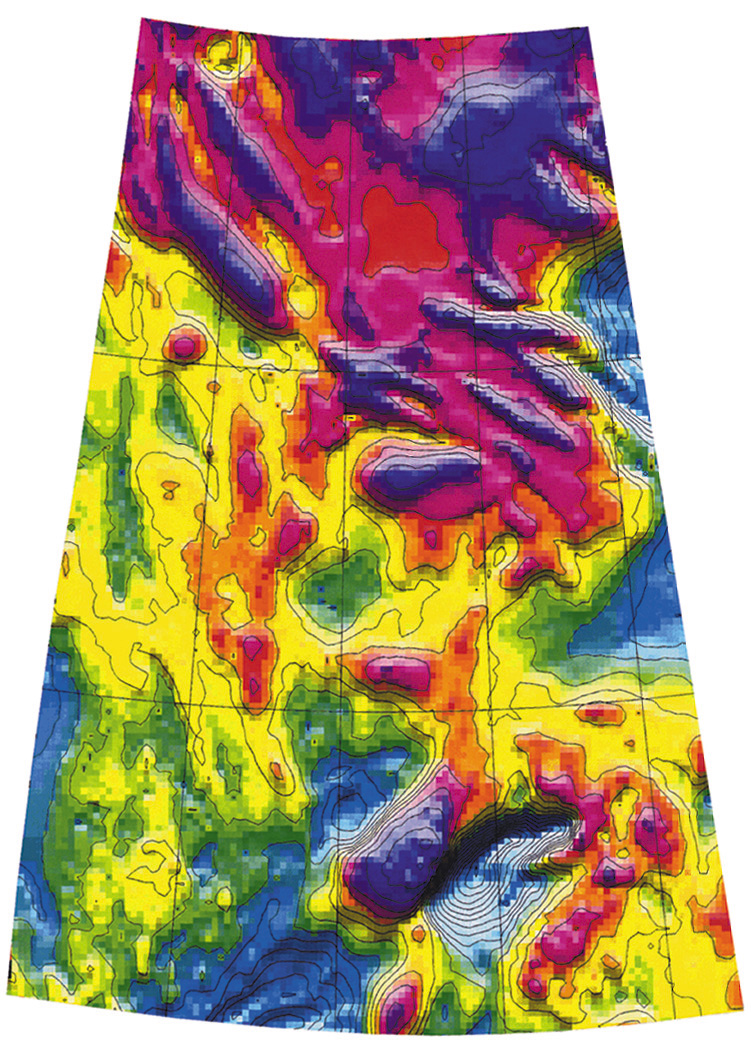 |
Figure 1. Map of the vertical gradient of the Bouguer gravity data over the northeastern part of the Siberian Craton.
Basement exposures in the Anabar Shield, and regional aeromagnetic data, have previously been used to map a series of Archean and Proterozoic basement terranes across the study area. We have analysed garnet concentrates and xenoliths from the chain of Paleozoic to Mesozoic kimberlites that crosses the region, to look at the thickness, composition and thermal state of the mantle lithosphere beneath these terranes. These studies showed that the Archean terranes are underlain by typical depleted Archean lithosphere up to 220 km thick, while the Proterozoic terranes to the north are underlain by thinner and less depleted lithosphere. Large differences in mantle "stratigraphy" between closely-spaced kimberlite fields suggest that the crustal terrane boundaries are near-vertical and cut through the whole lithosphere. |
An analysis of the flexural strength (Effective Elastic Thickness, or Te) was done, using gridded gravity and topography data. The most striking observation is that most of the study area, though geologically a stable Precambrian craton, has low Te values (<30 km), indicating a weak lithosphere like that of geologically much younger and more active zones. Paradoxically, the highest values of Te (30-40 km) are found over the Vilyui Aulacogen, a major Devonian rift zone in the SE quadrant of the study area where the lowest values would have been expected. The reasons for the low Te values are not clear, but a tectonic analysis suggests that they may be related to lithosphere deformation during accretion of the craton, or to the effects of several later episodes of crustal extension in the area.
The extension of this study to the west, planned for 1999, will examine the signature of the deep structure(s) (lithospheric) that have controlled the emplacement of the world-class Nor'ilsk nickel deposit.
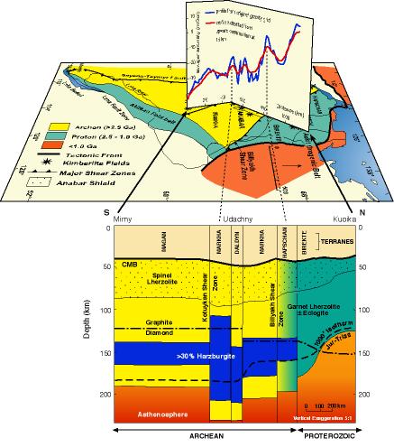
Figure 2. Upper: Terrane map for the northeastern Siberian craton with the variation in Bouguer anomaly overlaid along the main trends of the kimberlites. Lower: Structure of the lithosphere along the main kimberlite trend showing the more buoyant lithospheric keel beneath the Archean terranes. Publications: 139, 154 (Appendix 2)
Contact: W.L. Griffin, Y. Poudjom Djomani, L. Natapov, S. Y. O'Reilly
Funded by: Western Mining and Macquarie University
Part of GEMOC's Lithosphere Mapping, Metallogenesis and Geotectonics strands.
FROM THE MICRO TO THE MACRO OR: HAS THE EARTH CHANGED?
One of GEMOC'S research tools is a very large database of major- and trace-element analyses of garnet xenocrysts from volcanic rocks, built up through research related to diamond exploration. Statistical analysis of this database (with GEMOC Associate Nick Fisher of CSIRO Mathematics and Information Technology and Jerry Friedman of Stanford University) documented large differences in the types and composition of garnets derived from beneath various regions, and correlated these differences with the age of the last major thermal event in the crust. When statistically defined garnet populations were correlated with garnet compositions in real rocks (mantle-derived peridotite xenoliths) it became obvious that these small grains were carrying a very large-scale story about the way the Earth works.
In lithospheric mantle made after ca 2.5 Ga (billion years) ago, some kinds of rocks, especially strongly depleted harzburgites and lherzolites, simply do not occur, and the garnets of the main rock type in the younger mantle, the common lherzolites, become progressively less depleted in "incompatible" trace elements such as Y, Ti and Ga over the time span from 2.5 Ga to the present.
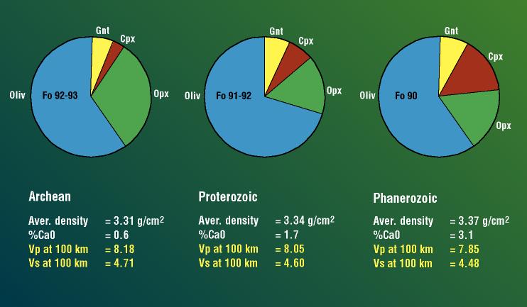 Differences kin Archean, Proterozoic an Phanerozoic mantle composition and physical properties.
| In the next step of this research, a correlation between the compositions of garnets and their host xenoliths showed that the composition of a lithospheric mantle section can be reliably calculated from the mean composition of its garnets. These calculations confirmed major changes in the composition of lithospheric mantle beneath terranes with Archean, Proterozoic and Phanerozoic crustal ages; younger lithospheric mantle is progressively less depleted in "basaltic" components. Using average mineral compositions measured in xenoliths, these compositions have been recast into mineral assemblages (modes), and used to derive the mean density and seismic velocities for mantle lithosphere of different ages. Archean lithospheric mantle is much less dense than Phanerozoic mantle, but has higher seismic velocities at any temperature; Proterozoic mantle lies between these two end-members.
The correlation of mantle composition with crustal age has important implications:
|
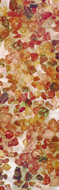
Mantle-derived garnet concentrate |
Publications: 90, 132, 139, 154 (Appendix 2 and Conference abstracts, Appendix 4)
Contact: W. L. Griffin and S.Y. O'Reilly
Funded by: ARC, Macquarie University, collaborative research with industry, ACILP, DIST
Part of GEMOC's Lithosphere Mapping strand.
CONTINENTAL FRAGMENTS WITHIN AN OCEANIC PLATEAU? THE AGULHAS PLATEAU, SW INDIAN OCEAN
Oceanic plateaux play a significant role in the growth of continents through the process of accretion. The Agulhas Plateau is one of the key structures within the reconstructions of the break-up of Gondwana with its crustal structure and palaeo-position still under debate. A new set of seismic reflection and deep crustal refraction lines has been interpreted to shed more light on the Late Cretaceous development of the plateau. Based on the ocean-bottom seismograph recordings, a deep crustal/upper mantle velocity-depth model has been produced which yields relatively high P-wave velocities of 7 km/s beginning at crustal depths of only 6-7 km. Observations of large-amplitude, high-velocity phases from shallow levels are consistent throughout the records from the central plateau. Prominent lower-crustal wide-angle reflections and refracted phases with apparent velocities of more than 8 km/s constrain the crust-mantle boundary (Moho) to a maximum depth of 24-25 km below sea-floor. An important result is the distribution of velocities between 7.0 and 7.6 km/s for the mid- to lower crust. As velocities of over 7 km/s represent mostly rock material of predominantly mafic and ultramafic composition, we interpret the Agulhas Plateau as of oceanic origin. Although a continental affinity was implied in earlier studies, based on the quartzo-feldspathic composition, high metamorphic grades and Cambrian and Proterozoic ages of some dredge samples, we do not see evidence for such materials in the seismic data. However, continental micro-fragments might be part of the western plateau which started to move from its attachment to the Falkland Plateau toward its present position at about 108-105 Ma. A large number of extrusive centres formed on the southern Agulhas Plateau, documenting the overprinting of the already overthickened oceanic crust. The high seismic velocities in the middle and lower crust and the evidence for major extrusive centres across the plateau are indicative of voluminous emplacement of predominantly mafic extrusive and intrusive rocks, the defining characteristics of Large Igneous Provinces.
Contact: Karsten Gohl
Funded by: MURG in collaboration with the Alfred Wagner Institute
Part of GEMOC's Lithosphere Mapping, Crustal Generation and Geotectonics strands.
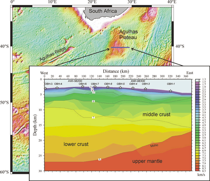 A recently-modelled velocity-depth distribution across the central Agulhas Plateau shows high P-wave velocities of above 7 km/s for up to 70% of its crustal thickness. The map represents a model of the sea-floor topography of the SE Atlantic and SW Indian Ocean region derived from satellite gravity.
During the Carboniferous to Permian, Australia moved from low to high latitudes. The apparent polar wander path (APWP) for Australia for this period is not well defined so a palaeomagnetic study of volcanic units from the southern part of the Connors-Camboon Province, of the Late Palaeozoic Northern New England Orogen in Queensland was carried out. The age range of the Province is 320 - 280 Ma, and this study concentrated on the Late Carboniferous Torsdale Volcanics and the Early Permian Camboon Volcanics from the Cracow area. The Camboon Volcanics sampled were generally andesitic ignimbrites and lavas yielding a primary direction in both magnetite and haematite carriers. All directions were reversed and initial analysis of the data shows a southerly steep down direction of Dec = 171.7°, Inc = 76.6° (_95 = 6.1°, k = 52, N=12) which results in a palaeomagnetic south pole of 50.4°S, 155.9°E (dp = 10.5, dm = 11.3; 11 in figure). This is consistent with other Australian Early Permian data such as the Mount Leyshon Complex and the Tuckers Igneous Complex. The Torsdale Volcanics sampled were generally silicic ignimbrites that yielded a primary direction in both magnetite and haematite carriers. Initial analysis shows that the directions are generally reversed, although some normal polarities are observed. The directions are not as steep as those observed for the Camboon Volcanics and show a more westerly character, with a mean direction of Dec = 217.8°, Inc=68.8° (_95 = 7.9°, k = 59, N=7) which results in a south pole of 50.9°S, 113.8°E (dp = 11.4, dm = 13.4; 10 in figure). The pole is consistent with the Late Carboniferous age of the unit.
Contact: Mark Lackie
Funded by: ARC, Macquarie University
Part of GEMOC's Lithosphere Mapping, and Geotectonics strands.
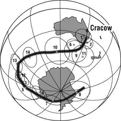 APWP for Australia from the Devonian (8) to Permian (1).
TRACE ELEMENTS IN THE CARBON OF YOUR CHOICE BY LAM-ICP-MS
Carbonaceous substances are commonly associated with economically important mineral resources - from inclusions of trapped liquid hydrocarbons to bituminous materials associated with major metalliferous deposits to diamonds.
The historical lack of trace element information on carbonaceous materials has been due to the lack of a reliable technique for in situ determination of low level trace elements in small volumes of these materials. We have recently developed a technique for analysis of both liquid and solid carbon-bearing substances using the GEMOC LAM-ICP-MS and have applied it to analysis of bituminous materials associated with the Oklo uranium deposits in Gabon and diamonds from several localities.
Calibration of the analyses is achieved by direct ablation of a synthetic oil standard encapsulated in a capillary tube; correction for ablation yield differences between calibration oil and sample is performed using carbon as an internal standard.
Our chemical analysis of trace elements in the bitumens at Okla has allowed identification of six different types, providing a major contribution to the understanding of the Oklo deposit.
The ability to rapidly and accurately determine a wide suite of trace elements in diamonds with high spatial resolution now offers the possibility of better understanding the genesis of diamonds and addressing such questions as:
- the nature of source regions and fluids, and the ultimate source of the carbon.
- are micro- and macro-diamonds generated by similar or different processes?
- are all diamond-forming processes similar, or are they dependent on mantle age, composition and environment?
Contact: Simon Jackson and Rondi Davies
Part of GEMOC's Lithosphere Mapping, Metallogenesis, and Technology and Development strands.
I-type granites of the Paleozoic fold belts of Eastern Australia were recognised to form two groups formed at high and low magmatic temperatures. The distinction is made on the absence or presence, respectively, of zircon with inherited ages in the more mafic rocks, and related differences in Zr variation patterns with SiO2. The high-temperature I-type granites, which include close analogues of Cordilleran tonalites, formed from a magma that was completely or largely molten, and in which crystals of zircon were not initially present because the melt was undersaturated in zircon. In contrast with the low-temperature I-type granites, the compositions extend to lower SiO2 contents and the abundances of Ba, Zr and the rare earth elements initially increase with increasing SiO2 in the more mafic rocks. While the high-temperature granite magmas were produced by the partial melting of mafic source rocks and represent a comparatively primitive addition to the upper crust, the low-temperature I-type granites resulted from the partial melting of quartzofeldspathic rocks such as older tonalites. In that second case the melt produced was felsic and the more mafic low-temperature granites have that character because of the presence of entrained and magmatically equilibrated restite which includes older zircon crystals. These low-temperature granites are effectively what Pitcher called Caledonian I-types. They may occur in close association with S-type granites since both are products of the magmatic recycling of older crust. There are also broad differences in composition between the I-type groups, with the Caledonian granites being more typically granodiorites and monzogranites. In contrast, tonalites and low-K granodiorites characterise the high-temperature Cordilleran granites, which have inherited that and associated features from their less evolved source materials.
Publication: 141 (Appendix 2)
Contact: Bruce Chappell
Part of GEMOC's Crustal Generation strand.<