 GEMOC ARC National Key Centre
Research highlights
(Numbered publications in Appendix 2)
Chromites from ultramafic rocks: guides to nickel, diamonds and the lithosphere
Chromite [(Mg,Fe)(Al,Cr,Fe)2O4] is a ubiquitous and important accessory mineral in mantle-derived ultramafic magmatic and metamorphic rocks, which are potential source rocks of diamond and other commodities such as Ni. Chromite has long been used as an indicator mineral in diamond exploration because it is very resistant to weathering and remains in the regolith after other indicators such as garnet are destroyed. However, other ultramafic rocks such as komatiites, which may host Ni deposits, also contain abundant chromite, which is similar in major-element composition to those from diamondiferous rocks. The GEMOC laser-ablation ICPMS microprobe (LAM-ICPMS) is being used to develop trace-element discriminants to improve the use of chromites in exploration for diamonds and komatiite-hosted Ni deposits. Detailed studies over the last two years have shown that the abundances of several trace elements, such as Co, Zn and Mn are closely related in mantle-derived chromites of all ages and tectonic setting, reflecting temperature-dependent partitioning between chromite and olivine. This Mantle Array we have defined for chromites has become a basic tool for distinguishing between mantle-derived xenocrysts and the chromites of ultramafic magmas such as komatiites. On a more detailed level, trace element analyses show marked differences in the chromites of Ni-bearing and barren komatiites, which appear to reflect the contamination of the Ni-bearing magmas with crustal material. These "fingerprints" can be used to recognise potentially mineralised flow units, before the ore has been found.
Kimberlites and other volcanic rocks generated near the lithosphere-asthenosphere boundary penetrate the whole lithosphere stratigraphy as they ascend to the surface, and carry up mantle xenocrysts, including chromite. If the chemistry of the chromite xenocrysts can be interpreted, they become tracers of mantle composition. The elements in the Mantle Array record temperature differences, and allow the original depth of each grain to be estimated. Our other studies show that the composition of lithospheric mantle has changed through time, and these differences also are showing up in the chromites. For example, chromites from Phanerozoic lithosphere generally are higher in Al and Ga than those from older lithosphere, reflecting lower degrees of depletion in basaltic components, while chromites from Archean lithosphere are significantly richer in V and Nb than those from younger mantle. Chromites will become progressively more important to our Lithosphere Mapping work as these studies proceed.
Contact: Bill Griffin and Shixin Yao; funded by Rio Tinto, Macquarie University, Industry consulting
Part of GEMOC's Lithosphere Mapping and Metallogenesis strands
Unique mantle history of eastern Australian diamonds: products of stress in a slab?
Over 1000 alluvial diamonds from several localities in eastern Australia have revealed that while all diamonds have similar surface textures that indicate transport to the surface in a magma, there are two distinctive groups (Publication 89). Group A (for Airly Mtn) is similar to diamonds from conventional kimberlitic occurrences in cratons in their inclusions, carbon isotopic compositions, internal morphology and old formation ages (from Re/Os compositions of sulphide inclusions).
However, Group B (for Bingara) is unique: forms are irregular and show strong deformation; their mineral inclusions reflect a Ca-rich eclogitic environment; and their carbon is isotopically heavy. Furthermore internal growth structures revealed in cathodoluminescence (CL) images (Figures 1, 2) show evidence of unstable and dynamic growth histories during which deformation has occurred simultaneously with diamond growth (Publication 110). This ubiquitous deformation in Group B diamonds is evident not as the fine cross-hatched linear features typical of plastic deformation in diamond, but as brittle displacements of layers, commonly with cataclastic disruption of layers and brecciation of internal structures (Figure 2).
Internal structures typical of the Group B diamonds include non-planar growth facets (Figure 1), resorption and disrupted central structures that have annealed and show subsequent overgrowths. Many diamonds show N-rich rounded cores (light CL) overgrown by N-poor (dark CL) diamond that may be overgrown, in turn, by an oscillating sequence of N-bearing and N-free layers with sharp contacts, suggesting growth under rapidly changing conditions. These structures are consistent with episodic growth and fluctuating fluid compositions and physical conditions (eg temperature and oxygen fugacity); a high strain field is necessary to explain the deformation features and is consistent with growth in an active subduction environment.
Contact: Rondi Davies; funded by Rio Tinto.
Part of GEMOC's Lithosphere Mapping and Metallogenesis strands
 |
Figure 1. Non-planar structures outside central zone. |
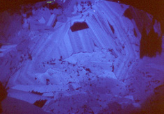 |
Figure 2. Cataclastic deformation structures. |
Are lithospheres forever?
The subcontinental lithospheric mantle (SCLM) carries a geochemical, thermal and chronological record of large-scale tectonic events that have shaped the Earth's crustal geological terrains. The SCLM is part of the continental plate, and moves with the plates over the less rigid asthenosphere. Development of the 4-D Lithosphere Mapping methodology (Publication 1) has provided tools for constructing realistic geological sections of the SCLM and for following the evolution of the lithosphere through time. Xenoliths and garnet and chromite xenocrysts from mantle-derived volcanics (eg basalts, lamproites, kimberlites) provide samples of the lithospheric mantle at the time of eruption. Where sufficient xenoliths and/or xenocrysts of appropriate composition are available, we can determine the paleogeotherm, the depth to the crust-mantle boundary, the detailed distribution of rock types with depth, the spatial distribution of fluid-related (metasomatic and anatectic) processes and the depth to the lithosphere-asthenosphere boundary within the tectosphere. Volcanic episodes of different ages in one region provide this information for different time-slices corresponding to ages of the volcanism, while geophysical data (seismic, gravity, magnetic, thermal) can be used to extend the geologically-derived profiles laterally or to interpret lithospheric domains with geophysical signatures that can be matched with geologically mapped sections.
Applications of 4-D lithosphere mapping have resulted in several new fundamental conclusions about lithosphere processes through time. Secular variation in lithosphere composition is revealed from the geochemical fingerprints of mantle xenoliths and disaggregated garnets. These data show that there have been episodic and irreversible changes in the composition of the SCLM from the Archean to the Phanerozoic and that the Archean/Proterozoic boundary represents a major change in the nature of lithosphere-forming processes (Publication 109). Lithosphere evolution and destruction mechanisms have been defined in some regions and appear to be characterised by lithosphere thinning and geochemical and thermal erosion. The Sino-Korean craton provides an excellent example: Ordovician kimberlites have sampled deep (200 km), cool, depleted (buoyant) Archean type mantle lithosphere while younger basaltic and kimberlitic volcanics contain mantle samples characterising thin (80 km), hot, fertile mantle with relatively low Vp of about 7.7 km/sec. A tomographic model of this region by Yuan (1996) is shown in figure 1, suggesting thinning and disruption of old mantle with high seismic velocity and replacement by new fertile, asthenospheric mantle. The new mantle corresponds to the fertile Phanerozoic type and would metasomatise and mix into the older disrupted SCLM. This disruption and dispersal of a 200 km thick Archean root was accompanied by uplift, basin formation and widespread magmatism.
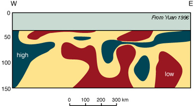
Figure 1. Velocity structure
Tectonic or magmatic events that lead to the replacement of old SCLM by such younger material cause changes in the density and geotherm of the lithospheric column, with major effects at the surface. In the Kaapvaal Craton (Figure 2, with icons showing fields for diamond and graphite) thermal and chemical erosion produced in a thinner, hotter and chemically recharged (metasomatised) lithosphere at about 90 million years, and led to significant uplift of the craton (Brown et al., 7IKC Abstract, 1998, Appendix 4).
In summary, correlations between mantle type and crustal age indicate that continental crust and its underlying SCLM were formed together and remain coupled for geologically long times. Destruction of Archean SCLM is difficult, but where it occurs, by thermal and chemical erosion and/or rifting, thinning and displacement, it has major thermal and tectonic consequences and affects geophysical properties (Publications 90, 109, Appendix 2).
Contact: S.Y. O'Reilly and W. L. Griffin and the Lithosphere Modelling Group: funded by ARC, Macquarie University, Collaborative research with industry, ACILP, DEETYA TIL
Part of GEMOC's Lithosphere Mapping strand
Chemical tomography of the northern Siberian Platform: imaging the lithosphere
The kimberlite fields of the northern Siberian Platform sample the mantle to depths of about 200 km along a 1000-km traverse stretching from the Malo-Botuobiya field in the SW to the Kuoika field in the NE. This traverse crosses several major terrane boundaries mapped using surface geology and geophysics, including a major discontinuity between the Archean part of the craton in the south and the Proterozoic part in the north. Over 6,000 garnet and chromite xenocrysts from 14 of these fields have been used to map the distribution of mantle rock types along this traverse. Nickel and Zinc Thermometry have been used to derive the paleogeotherm at each point (Publication 92) and a depth of derivation for each xenocryst. The garnets have been assigned to one of 5 rock types, using their Ca and Cr contents. The figure shows the vertical and lateral distribution of these rock types along the traverse, and outlines several important geological features. Harzburgitic rocks are restricted to the southern portions of the craton which have Archean crust; the Archean-Proterozoic boundary is clearly visible in the central portion of the figure. Under the Archean part of the traverse, the lithosphere-asthenosphere boundary is delineated by the Ca-harzburgites, and shows significant topography. The low-Cr rocks are fertile lherzolites, and appear especially in the right centre, where the traverse crosses an Upper Precambrian rift zone. The low-Cr rocks at depths >150 km probably represent magmatic intrusion into the lower lithosphere, and show the rise in the lithosphere-asthenosphere boundary beneath the rift. Large vertical offsets in mantle stratigraphy within the Archean part of the craton reflect mapped terrane boundaries, which appear to be translithospheric sutures. Images like this let us map major lithospheric structures, their boundaries (likely to be the sites of world-class ore deposits of such commodities as nickel) and provide new data about how continents form. The next stage of this work will use regional geophysics to map these structures laterally into areas where kimberlites are not available.
Contact: W.L. Griffin, S. Y. O'Reilly, C. Ryan: original project funded by ARC and RTZ Exploration; next stage funded by Western Mining Corp. and Macquarie University.
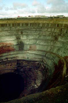 |
Window to the lithosphere The Mir diamond mine has yielded some of the mantle xenoliths, mineral concentrates and diamonds that have been some of the tools for constructing the chemical tomography section across northern Siberia. |
Part of GEMOC's Lithosphere Mapping and Geotectonics strands
All cratons are not created equal: Lithosphere Structure and Mantle Terranes, Slave Craton, Canada
Xenoliths and heavy mineral concentrates have been used to map the composition, structure and thermal state of the lithospheric mantle beneath the Slave craton in northwestern Canada. Beneath the Lac de Gras area in the centre of the craton, the lithosphere is 200-220 km thick, and a sharp boundary between two layers of the lithospheric mantle is defined by plots of trace- and major-element data vs Nickel Temperature (TNi) for concentrate garnets. Projection of the temperature of this boundary (Å900 °C) to the geotherm derived from xenoliths and concentrates places it at a depth of 150±10 km. Above this boundary, the mantle consists of ultradepleted rocks dominated by harzburgites, while from 150 km to the lithosphere-asthenosphere boundary (LAB) the major rock type is a moderately depleted lherzolite. T estimates on eclogite xenoliths show that they are concentrated in the deeper layer, and especially near the LAB. Our studies of the diamonds from this area show that a large proportion contain a "superdeep" inclusion suite, with minerals that have formed at depths >650 km (Davies et al., 1998). This suggests that the deeper layer of the lithosphere rose as a diapir from near the core-mantle boundary, and spread out below a thinner pre-existing lithosphere that may have been formed during craton assembly (>2.6 Ga). The heat supplied by the lithospheric underplating may have helped generate the extensive 2.6 Ga granite suite of the Slave Craton. The two-layered lithosphere has been traced over an area of ca 1800 km2 around Lac de Gras; at greater distances the shallow ultradepleted layer appears to thin, and the deeper layer and the LAB rise to shallower depths.
This integrated study of diamonds (and their inclusions), xenoliths and concentrate minerals has shown that the Slave craton has a unique lithosphere structure, and gives us clues to the interpretation of other cratons worldwide.
 |
Contact: W.L. Griffin, S. Y. O'Reilly, N.J. Pearson; project funded by Kennecott Canada Inc. and Macquarie University.
Part of GEMOC's Lithosphere Mapping, Metallogenesis and Geotectonics strands |
Zircon -- a brilliant petrological recorder
Zircon (ZrSiO4) is a common accessory in a wide range of igneous rocks ranging from basic to felsic in composition. It is highly stable and resistant, so that it can survive partial melting processes and hydrothermal activity as well as weathering and transport. Magmatic zircon typically shows pronounced internal zoning, which can be observed in polished sections using a combination of high-resolution backscattered-electron (BSE) and cathodoluminescence (CL) imaging. (See zircon image in the Technology Development section).
This zoning, which reflects minor compositional variations, records changes in the external morphology of the crystals during their growth in the magma. The morphology of zircon is complex, with the development of different crystal forms related to both temperature and magma composition, and the internal zoning thus provides a qualitative tape recorder of changes in these parameters. The GEMOC laser-ablation ICPMS microprobe (LAM ICPMS) allows us to analyse up to 30 elements in zircon at low ppb detection limits, with a spatial resolution of 30-40 microns. With these data, we can correlate changes in internal morphology with changes in trace element chemistry, and the composition of the magma at each stage of crystallisation then can be calculated by using experimentally-derived and empirical distribution coefficients. In several Australian examples, this approach has provided clear evidence of complex magmatic histories, with linked changes in temperature and magma composition. The technique now will be used, together with analysis of Hf and Pb isotopes by the new multi-collector ICPMS laser-ablation microprobe, to study the evolution of granites in eastern China, as part of a study of crust-mantle interactions.
Most crustal zircons show yellow excitation colours under the cathodoluminescence microscope, while most mantle-derived zircons (from kimberlites) show blue-violet colours. These differences appear to be related to trace-element contents. LAM-ICPMS data show that kimberlite zircons have distinctive trace element patterns, with well defined ranges for REE, Y, U, Th and P as well as chondrite-normalised REE patterns with low and flat HREE. Rare yellow-luminescing zones in kimberlitic zircons have higher U, Th, Y, and REE than those with blue-violet CL. This suggests that variations in luminescence colours reflect an interplay between elements such as the REE, which give blue colours, and lattice defects, which give yellow colours.
This study is providing base-line data using our new technology to provide a framework for mineral exploration.
| Cathodoluminescence image of zircon from Yakutian kimberlite (Russia) shows inherited core with thin oscillatory zoning overgrown by a homogeneous rim. | 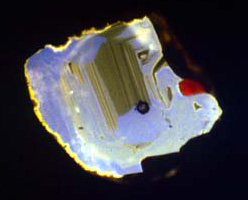 |
Contact: Bill Griffin, Elena Belousova; funded by Rio Tinto, BHP, Macquarie University
Part of GEMOC's Crustal Generation and Metallogenesis strands
Island Arc-Oceanic Plateau Collision; Santa Isabel, Solomon Islands
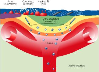
On Santa Isabel in the northeastern Solomon Islands arc, exposed rock units include: pillow basalts of the world's largest known "flood basalt" province, the Ontong Java Plateau (OJP); gabbros and refractory peridotites (representing the upper mantle residues from melting during formation of the pillow basalts); fault-slices and serpentinite diapirs of supra-subduction zone mantle. These rock sequences comprise the essential components of an ophiolite, except that sheeted dykes are not present, and represent the first reported occurrence of deep portions of the OJP. A 2 km stratigraphic lava sequence yields strictly bi-modal 40Ar/39Ar ages of 122±1 and 90±1 Ma, the same as basalts recovered by Ocean Drilling Program Leg 130 ~ 2000 km away on the OJP. Four chemically-distinctive basalt groups occur on Santa Isabel, three of which are similar to ODP Leg 130 basalts. Lavas erupted at 122 and 90 Ma are modelled as high degree melts of peridotite, most likely within a mantle plume head which impacted beneath thin oceanic lithosphere. The peridotites have origins ranging from harzburgite residues from a supra-subduction zone setting to lherzolite residues of melting processes which generated the OJP. Of particular interest is the nature of the spinel phases included within the various peridotite types - these vary in composition from abyssal-peridotite-like through highly refractory Cr-rich to highly oxidised (Fe3+-rich). Juxtaposition of peridotites with contrasting melting histories may be diagnostic of oceanic plateau collision at a convergent margin. The exposed OJP shows limited signs of being subducted, and may form a thick lithospheric cap under which subduction zone melts will be generated. Modification of the OJP by these melts and eventual collision with a continent will complete a sequence of continental crustal growth formed both by mantle plume and supra-subduction zone processes.
Contact: R. J. Arculus; project funded by ARC
Part of GEMOC's Crustal Generation strand
The petrology and mineralisation of the plutonic roots of an island arc magmatic system - the Greenhills Complex, New Zealand.
The Greenhills complex is an Early Permian, ultramafic-mafic layered igneous intrusion comprising thick sequences of dunite, olivine clinopyroxenite, olivine gabbro and hornblende gabbro-norite, enclosed by a ring dyke and cut by numerous other doleritic dykes. The complex is part of the Brook Street Terrane, probably originally formed in an intra-oceanic arc setting, correlative with the Gympie Province of northeastern Australia, and accreted to the eastern margin of Gondwana. The bulk of the complex was formed by fractional crystallisation of mafic magma. On the basis of the crystallisation sequence, mineral compositions, calculated oxygen fugacities, and trace element compositions of (re-heated, homogenised) former melt inclusions in chromite, we infer that the parental melts of the Greenhills rocks were primitive, low-K island arc tholeiites. Both primary and secondary platinum group element (PGE) minerals are preserved in chrome spinel-rich pods in dunite, and are likely the source of alluvial platinum minerals distributed along the coast to the east of the complex.
Contact: C. Spandler, R. J. Arculus, S.M. Eggins & J. Mavrogenes; project funded by ARC in collaboration with R.C. Price (University of Waikato) and A. Reay (University of Otago)
Part of GEMOC's Crustal Generation and Metallogenesis strands